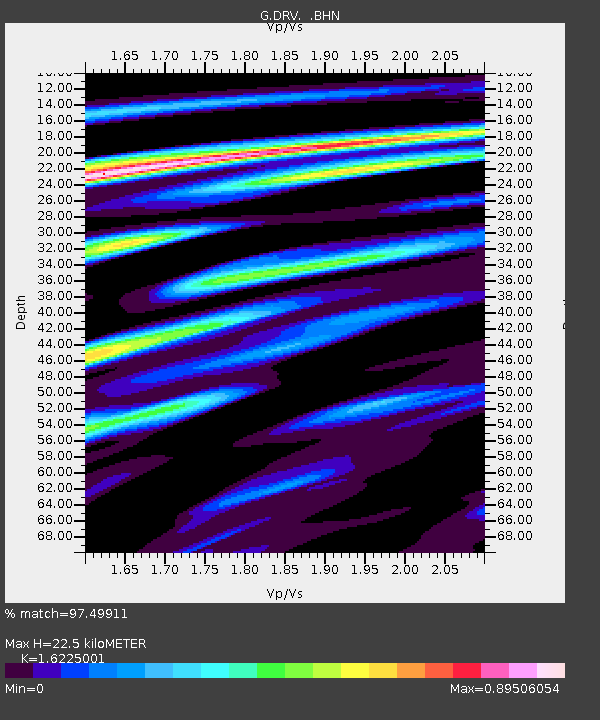
DRV Dumont d'Urville, Terre Adelie (Antartica) - Earthquake Result Viewer
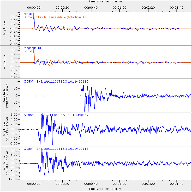
Earthquake location: Kermadec Islands, New Zealand
Earthquake latitude/longitude: -30.1/-178.0
Earthquake time(UTC): 1991/11/01 (305) 16:23:26 GMT
Earthquake Depth: 48 km
Earthquake Magnitude: 6.4 MB, 6.5 MS, 6.7 UNKNOWN
Earthquake Catalog/Contributor: WHDF/NEIC
Network: G GEOSCOPE
Station: DRV Dumont d'Urville, Terre Adelie (Antartica)
Lat/Lon: 66.67 S/140.01 E
Elevation: 40 m
Distance: 44.4 deg
Az: 202.391 deg
Baz: 55.955 deg
Ray Param: 0.07181141
Estimated Moho Depth: 22.5 km
Estimated Crust Vp/Vs: 1.62
Assumed Crust Vp: 6.39 km/s
Estimated Crust Vs: 3.938 km/s
Estimated Crust Poisson's Ratio: 0.19
Radial Match: 97.49911 %
Radial Bump: 363
Transverse Match: 91.45033 %
Transverse Bump: 400
SOD ConfigId: 16938
Insert Time: 2010-02-26 21:58:12.758 +0000
GWidth: 2.5
Max Bumps: 400
Tol: 0.001

Signal To Noise

ChannelStoNSTALTA
G:DRV: :BHN:19911101T16:31:01.949011Z19.0133082.0091459E-61.056705E-7
G:DRV: :BHE:19911101T16:31:01.949011Z23.3683552.5046263E-61.07180256E-7
G:DRV: :BHZ:19911101T16:31:01.949011Z45.9370965.4097454E-61.1776421E-7
Arrivals
Ps2.4 SECOND
PpPs8.6 SECOND
PsPs/PpSs11 SECOND