You are here: Home > Network List > G - GEOSCOPE Stations List
> Station DRV Dumont d'Urville, Terre Adelie (Antartica) > Earthquake Result Viewer
DRV Dumont d'Urville, Terre Adelie (Antartica) - Earthquake Result Viewer
| Earthquake location: |
Mindanao, Philippines |
| Earthquake latitude/longitude: |
8.4/126.4 |
| Earthquake time(UTC): |
1991/11/13 (317) 11:12:12 GMT |
| Earthquake Depth: |
33 km |
| Earthquake Magnitude: |
6.1 MB, 6.4 MS, 6.5 UNKNOWN |
| Earthquake Catalog/Contributor: |
WHDF/NEIC |
|
| Network: |
G GEOSCOPE |
| Station: |
DRV Dumont d'Urville, Terre Adelie (Antartica) |
| Lat/Lon: |
66.67 S/140.01 E |
| Elevation: |
40 m |
|
| Distance: |
75.5 deg |
| Az: |
174.453 deg |
| Baz: |
346.107 deg |
| Ray Param: |
0.051597748 |
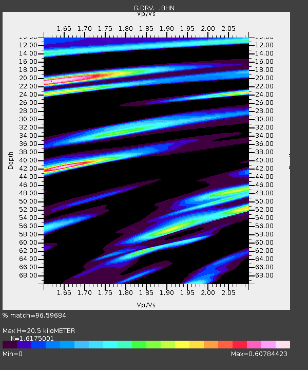
| Estimated Moho Depth: |
20.5 km |
| Estimated Crust Vp/Vs: |
1.62 |
| Assumed Crust Vp: |
6.39 km/s |
| Estimated Crust Vs: |
3.95 km/s |
| Estimated Crust Poisson's Ratio: |
0.19 |
|
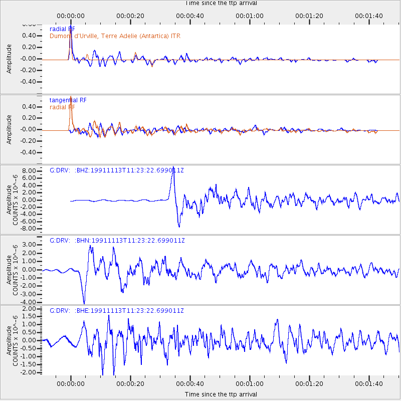
| Radial Match: |
96.59684 % |
| Radial Bump: |
392 |
| Transverse Match: |
90.5889 % |
| Transverse Bump: |
400 |
| SOD ConfigId: |
16938 |
| Insert Time: |
2010-02-26 21:58:14.500 +0000 |
| GWidth: |
2.5 |
| Max Bumps: |
400 |
| Tol: |
0.001 |
|
Signal To Noise
| Channel | StoN | STA | LTA |
| G:DRV: :BHN:19911113T11:23:22.699011Z | 15.504788 | 1.5758978E-6 | 1.0163942E-7 |
| G:DRV: :BHE:19911113T11:23:22.699011Z | 5.1117325 | 5.168715E-7 | 1.0111474E-7 |
| G:DRV: :BHZ:19911113T11:23:22.699011Z | 25.36018 | 3.5056921E-6 | 1.3823609E-7 |
| Arrivals |
| Ps | 2.1 SECOND |
| PpPs | 8.1 SECOND |
| PsPs/PpSs | 10 SECOND |


