You are here: Home > Network List > TA - USArray Transportable Network (new EarthScope stations) Stations List
> Station 348A Jackson, AL, USA > Earthquake Result Viewer
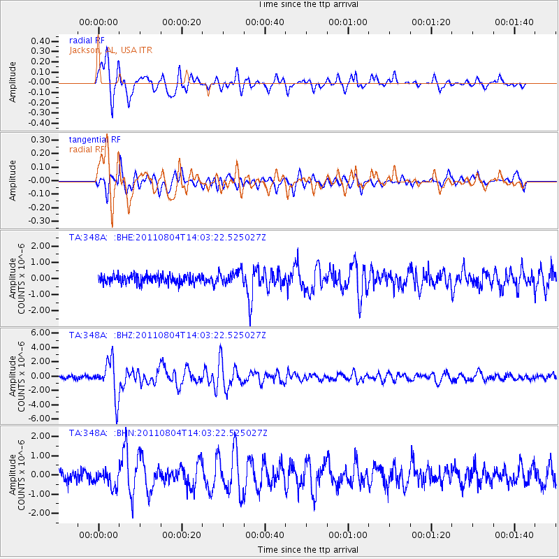
348A Jackson, AL, USA - Earthquake Result Viewer
*The percent match for this event was below the threshold and hence no stack was calculated.
| Earthquake location: |
Kuril Islands |
| Earthquake latitude/longitude: |
48.8/154.8 |
| Earthquake time(UTC): |
2011/08/04 (216) 13:51:34 GMT |
| Earthquake Depth: |
36 km |
| Earthquake Magnitude: |
6.0 MB, 5.8 MS, 6.1 MW, 6.0 MW |
| Earthquake Catalog/Contributor: |
WHDF/NEIC |
|
| Network: |
TA USArray Transportable Network (new EarthScope stations) |
| Station: |
348A Jackson, AL, USA |
| Lat/Lon: |
31.41 N/87.90 W |
| Elevation: |
57 m |
|
| Distance: |
82.5 deg |
| Az: |
50.001 deg |
| Baz: |
323.699 deg |
| Ray Param: |
$rayparam |
*The percent match for this event was below the threshold and hence was not used in the summary stack. |
|
| Radial Match: |
92.99185 % |
| Radial Bump: |
400 |
| Transverse Match: |
84.76891 % |
| Transverse Bump: |
400 |
| SOD ConfigId: |
408116 |
| Insert Time: |
2012-01-01 04:40:00.516 +0000 |
| GWidth: |
2.5 |
| Max Bumps: |
400 |
| Tol: |
0.001 |
|
Signal To Noise
| Channel | StoN | STA | LTA |
| TA:348A: :BHZ:20110804T14:03:22.525027Z | 14.176635 | 2.6401342E-6 | 1.8623138E-7 |
| TA:348A: :BHN:20110804T14:03:22.525027Z | 1.6526629 | 4.4233724E-7 | 2.6765122E-7 |
| TA:348A: :BHE:20110804T14:03:22.525027Z | 1.640561 | 4.0779668E-7 | 2.4857147E-7 |
| Arrivals |
| Ps | |
| PpPs | |
| PsPs/PpSs | |


