You are here: Home > Network List > TA - USArray Transportable Network (new EarthScope stations) Stations List
> Station Z42A Norrel Spur, Hamburg, AR, USA > Earthquake Result Viewer
Z42A Norrel Spur, Hamburg, AR, USA - Earthquake Result Viewer
| Earthquake location: |
Kuril Islands |
| Earthquake latitude/longitude: |
48.8/154.8 |
| Earthquake time(UTC): |
2011/08/04 (216) 13:51:34 GMT |
| Earthquake Depth: |
36 km |
| Earthquake Magnitude: |
6.0 MB, 5.8 MS, 6.1 MW, 6.0 MW |
| Earthquake Catalog/Contributor: |
WHDF/NEIC |
|
| Network: |
TA USArray Transportable Network (new EarthScope stations) |
| Station: |
Z42A Norrel Spur, Hamburg, AR, USA |
| Lat/Lon: |
33.27 N/91.95 W |
| Elevation: |
39 m |
|
| Distance: |
79.0 deg |
| Az: |
51.624 deg |
| Baz: |
321.805 deg |
| Ray Param: |
0.04921886 |
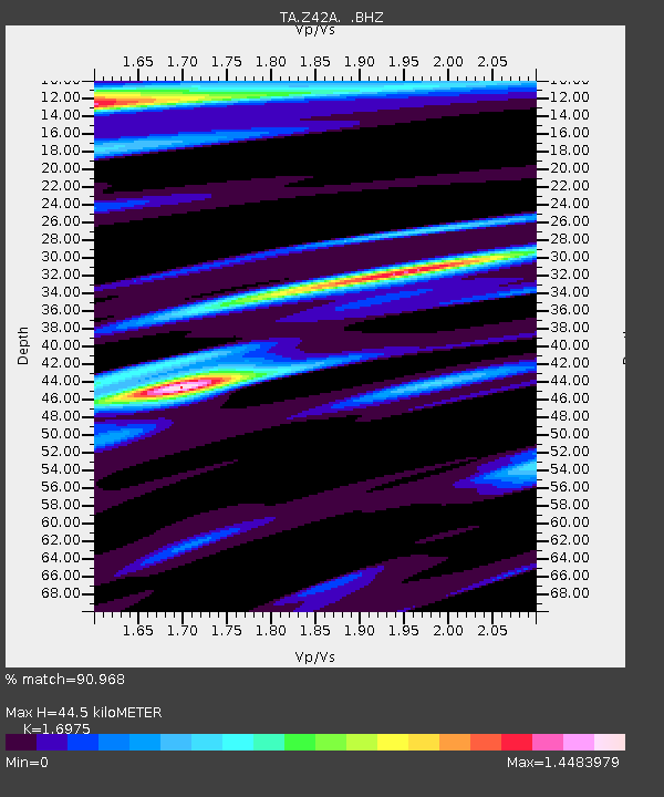
| Estimated Moho Depth: |
44.5 km |
| Estimated Crust Vp/Vs: |
1.70 |
| Assumed Crust Vp: |
6.201 km/s |
| Estimated Crust Vs: |
3.653 km/s |
| Estimated Crust Poisson's Ratio: |
0.23 |
|
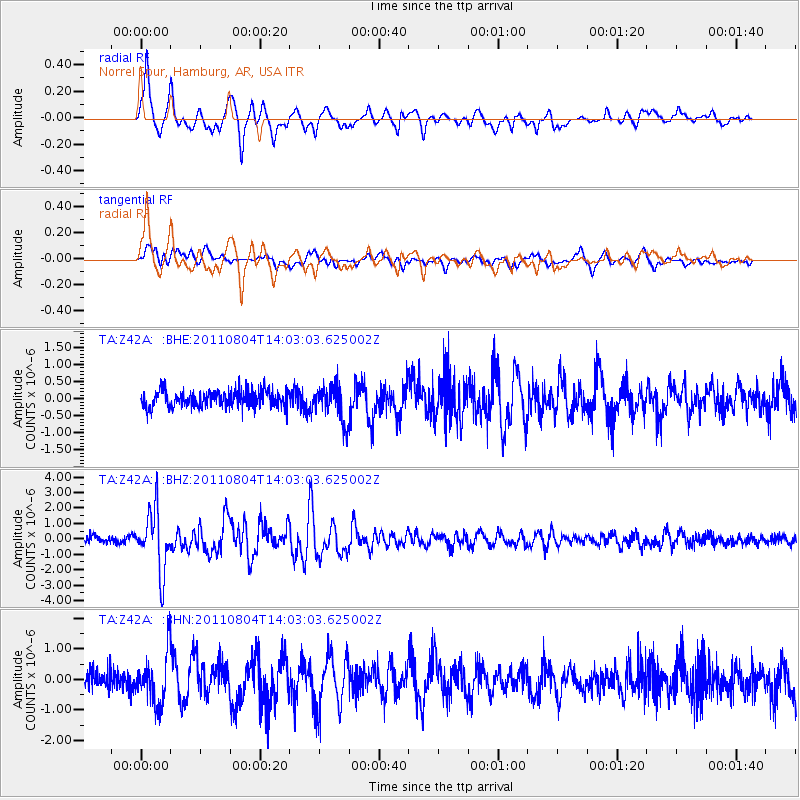
| Radial Match: |
90.968 % |
| Radial Bump: |
400 |
| Transverse Match: |
77.23105 % |
| Transverse Bump: |
400 |
| SOD ConfigId: |
408116 |
| Insert Time: |
2012-01-01 04:41:35.022 +0000 |
| GWidth: |
2.5 |
| Max Bumps: |
400 |
| Tol: |
0.001 |
|
Signal To Noise
| Channel | StoN | STA | LTA |
| TA:Z42A: :BHZ:20110804T14:03:03.625002Z | 10.650934 | 1.9393408E-6 | 1.8208175E-7 |
| TA:Z42A: :BHN:20110804T14:03:03.625002Z | 2.9297879 | 8.244594E-7 | 2.8140582E-7 |
| TA:Z42A: :BHE:20110804T14:03:03.625002Z | 2.1651168 | 5.264742E-7 | 2.4316202E-7 |
| Arrivals |
| Ps | 5.1 SECOND |
| PpPs | 19 SECOND |
| PsPs/PpSs | 24 SECOND |


