You are here: Home > Network List > TA - USArray Transportable Network (new EarthScope stations) Stations List
> Station Z43A Armstrong Family, Eudora, AR, USA > Earthquake Result Viewer
Z43A Armstrong Family, Eudora, AR, USA - Earthquake Result Viewer
| Earthquake location: |
Kuril Islands |
| Earthquake latitude/longitude: |
48.8/154.8 |
| Earthquake time(UTC): |
2011/08/04 (216) 13:51:34 GMT |
| Earthquake Depth: |
36 km |
| Earthquake Magnitude: |
6.0 MB, 5.8 MS, 6.1 MW, 6.0 MW |
| Earthquake Catalog/Contributor: |
WHDF/NEIC |
|
| Network: |
TA USArray Transportable Network (new EarthScope stations) |
| Station: |
Z43A Armstrong Family, Eudora, AR, USA |
| Lat/Lon: |
33.21 N/91.24 W |
| Elevation: |
39 m |
|
| Distance: |
79.4 deg |
| Az: |
51.192 deg |
| Baz: |
322.108 deg |
| Ray Param: |
0.0489358 |
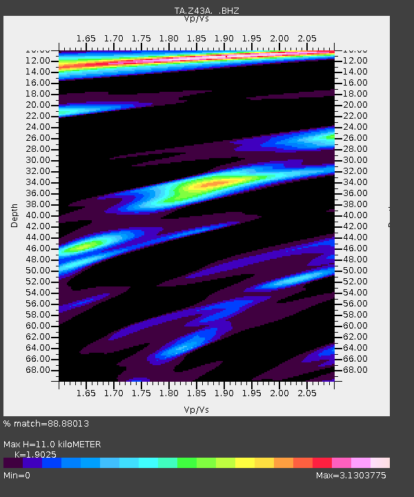
| Estimated Moho Depth: |
11.0 km |
| Estimated Crust Vp/Vs: |
1.90 |
| Assumed Crust Vp: |
6.201 km/s |
| Estimated Crust Vs: |
3.26 km/s |
| Estimated Crust Poisson's Ratio: |
0.31 |
|
| Radial Match: |
88.88013 % |
| Radial Bump: |
400 |
| Transverse Match: |
61.44382 % |
| Transverse Bump: |
400 |
| SOD ConfigId: |
408116 |
| Insert Time: |
2012-01-01 04:41:47.902 +0000 |
| GWidth: |
2.5 |
| Max Bumps: |
400 |
| Tol: |
0.001 |
|
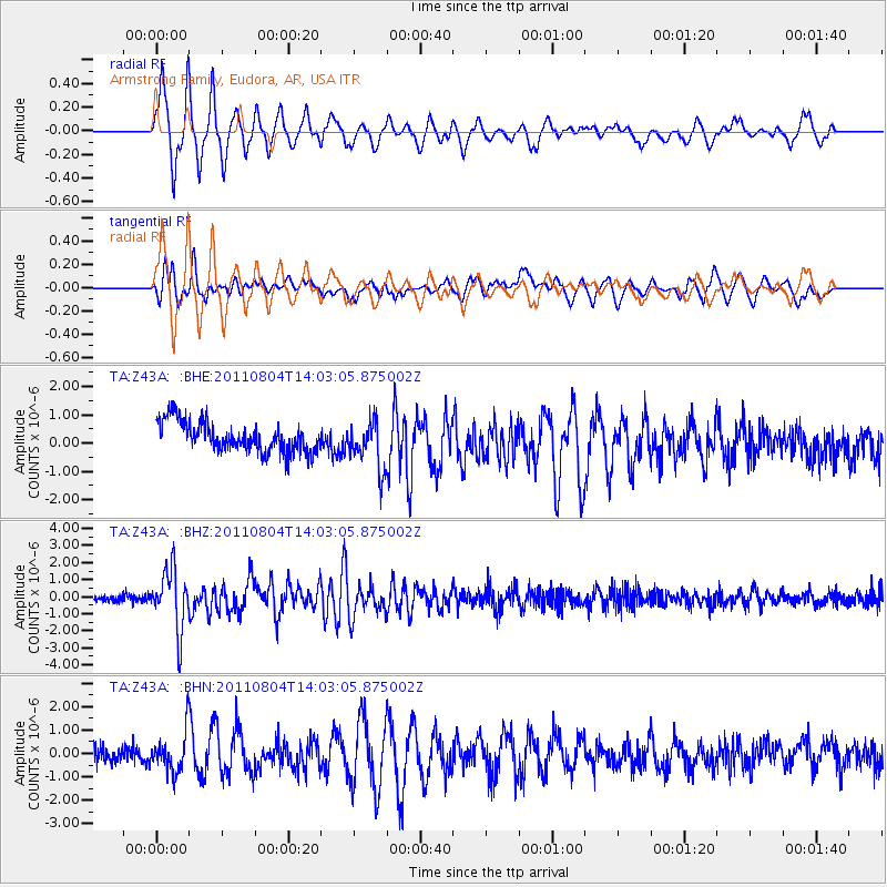
Signal To Noise
| Channel | StoN | STA | LTA |
| TA:Z43A: :BHZ:20110804T14:03:05.875002Z | 8.6508465 | 1.7555305E-6 | 2.0293164E-7 |
| TA:Z43A: :BHN:20110804T14:03:05.875002Z | 2.2541692 | 8.412466E-7 | 3.7319583E-7 |
| TA:Z43A: :BHE:20110804T14:03:05.875002Z | 1.6311202 | 8.616127E-7 | 5.282337E-7 |
| Arrivals |
| Ps | 1.6 SECOND |
| PpPs | 5.0 SECOND |
| PsPs/PpSs | 6.7 SECOND |


