You are here: Home > Network List > G - GEOSCOPE Stations List
> Station DRV Dumont d'Urville, Terre Adelie (Antartica) > Earthquake Result Viewer
DRV Dumont d'Urville, Terre Adelie (Antartica) - Earthquake Result Viewer
| Earthquake location: |
Southeast Of Loyalty Islands |
| Earthquake latitude/longitude: |
-23.4/171.1 |
| Earthquake time(UTC): |
1991/12/11 (345) 20:39:38 GMT |
| Earthquake Depth: |
34 km |
| Earthquake Magnitude: |
5.6 MB, 6.5 MS, 6.3 UNKNOWN |
| Earthquake Catalog/Contributor: |
WHDF/NEIC |
|
| Network: |
G GEOSCOPE |
| Station: |
DRV Dumont d'Urville, Terre Adelie (Antartica) |
| Lat/Lon: |
66.67 S/140.01 E |
| Elevation: |
40 m |
|
| Distance: |
47.5 deg |
| Az: |
196.187 deg |
| Baz: |
40.014 deg |
| Ray Param: |
0.06988499 |
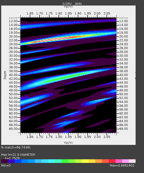
| Estimated Moho Depth: |
21.5 km |
| Estimated Crust Vp/Vs: |
1.75 |
| Assumed Crust Vp: |
6.39 km/s |
| Estimated Crust Vs: |
3.646 km/s |
| Estimated Crust Poisson's Ratio: |
0.26 |
|
| Radial Match: |
96.74491 % |
| Radial Bump: |
336 |
| Transverse Match: |
85.81725 % |
| Transverse Bump: |
400 |
| SOD ConfigId: |
16938 |
| Insert Time: |
2010-02-26 21:58:18.462 +0000 |
| GWidth: |
2.5 |
| Max Bumps: |
400 |
| Tol: |
0.001 |
|
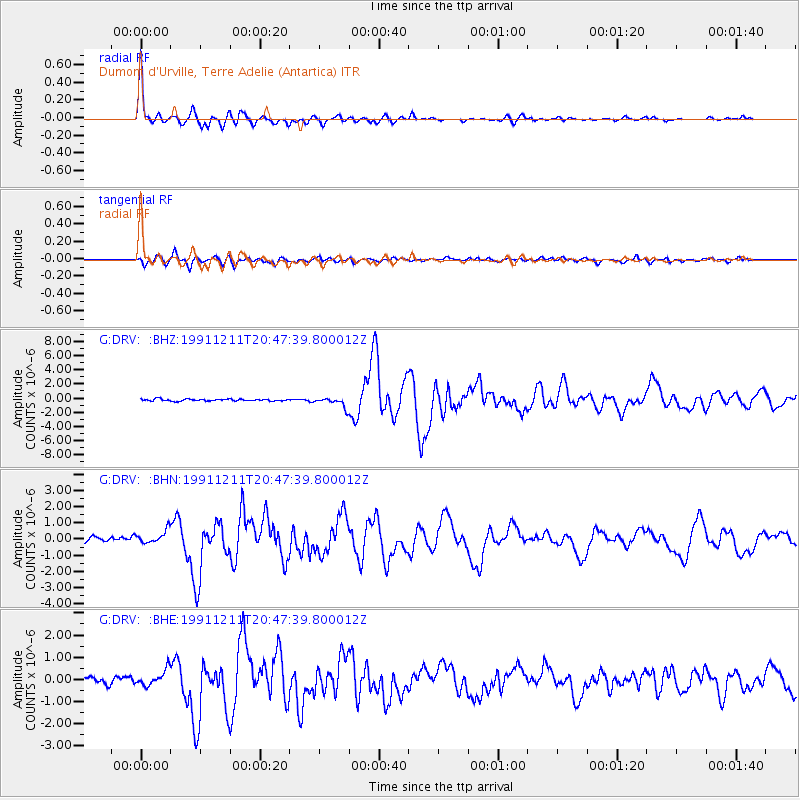
Signal To Noise
| Channel | StoN | STA | LTA |
| G:DRV: :BHN:19911211T20:47:39.800012Z | 2.267108 | 4.3315453E-7 | 1.9106038E-7 |
| G:DRV: :BHE:19911211T20:47:39.800012Z | 1.8287762 | 3.561872E-7 | 1.9476806E-7 |
| G:DRV: :BHZ:19911211T20:47:39.800012Z | 4.9815073 | 6.897067E-7 | 1.3845343E-7 |
| Arrivals |
| Ps | 2.7 SECOND |
| PpPs | 8.7 SECOND |
| PsPs/PpSs | 11 SECOND |


