You are here: Home > Network List > TA - USArray Transportable Network (new EarthScope stations) Stations List
> Station L39A Vinton, IA, USA > Earthquake Result Viewer
L39A Vinton, IA, USA - Earthquake Result Viewer
| Earthquake location: |
Kuril Islands |
| Earthquake latitude/longitude: |
48.8/154.8 |
| Earthquake time(UTC): |
2011/08/04 (216) 13:51:34 GMT |
| Earthquake Depth: |
36 km |
| Earthquake Magnitude: |
6.0 MB, 5.8 MS, 6.1 MW, 6.0 MW |
| Earthquake Catalog/Contributor: |
WHDF/NEIC |
|
| Network: |
TA USArray Transportable Network (new EarthScope stations) |
| Station: |
L39A Vinton, IA, USA |
| Lat/Lon: |
42.12 N/92.00 W |
| Elevation: |
261 m |
|
| Distance: |
72.1 deg |
| Az: |
45.929 deg |
| Baz: |
320.346 deg |
| Ray Param: |
0.0538428 |
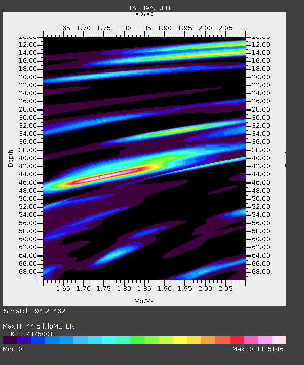
| Estimated Moho Depth: |
44.5 km |
| Estimated Crust Vp/Vs: |
1.74 |
| Assumed Crust Vp: |
6.53 km/s |
| Estimated Crust Vs: |
3.759 km/s |
| Estimated Crust Poisson's Ratio: |
0.25 |
|
| Radial Match: |
94.21462 % |
| Radial Bump: |
355 |
| Transverse Match: |
81.494255 % |
| Transverse Bump: |
388 |
| SOD ConfigId: |
408116 |
| Insert Time: |
2012-01-01 04:45:07.081 +0000 |
| GWidth: |
2.5 |
| Max Bumps: |
400 |
| Tol: |
0.001 |
|
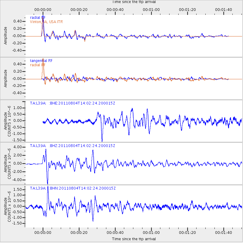
Signal To Noise
| Channel | StoN | STA | LTA |
| TA:L39A: :BHZ:20110804T14:02:24.200015Z | 19.548311 | 1.9347867E-6 | 9.8974624E-8 |
| TA:L39A: :BHN:20110804T14:02:24.200015Z | 6.00161 | 6.627888E-7 | 1.1043516E-7 |
| TA:L39A: :BHE:20110804T14:02:24.200015Z | 6.8717747 | 5.829556E-7 | 8.483333E-8 |
| Arrivals |
| Ps | 5.2 SECOND |
| PpPs | 18 SECOND |
| PsPs/PpSs | 23 SECOND |


