You are here: Home > Network List > TA - USArray Transportable Network (new EarthScope stations) Stations List
> Station J41A Loganville, WI, USA > Earthquake Result Viewer
J41A Loganville, WI, USA - Earthquake Result Viewer
| Earthquake location: |
Kuril Islands |
| Earthquake latitude/longitude: |
48.8/154.8 |
| Earthquake time(UTC): |
2011/08/04 (216) 13:51:34 GMT |
| Earthquake Depth: |
36 km |
| Earthquake Magnitude: |
6.0 MB, 5.8 MS, 6.1 MW, 6.0 MW |
| Earthquake Catalog/Contributor: |
WHDF/NEIC |
|
| Network: |
TA USArray Transportable Network (new EarthScope stations) |
| Station: |
J41A Loganville, WI, USA |
| Lat/Lon: |
43.37 N/90.01 W |
| Elevation: |
360 m |
|
| Distance: |
72.0 deg |
| Az: |
43.912 deg |
| Baz: |
321.069 deg |
| Ray Param: |
0.053865295 |
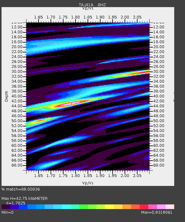
| Estimated Moho Depth: |
42.75 km |
| Estimated Crust Vp/Vs: |
1.78 |
| Assumed Crust Vp: |
6.53 km/s |
| Estimated Crust Vs: |
3.664 km/s |
| Estimated Crust Poisson's Ratio: |
0.27 |
|
| Radial Match: |
89.00836 % |
| Radial Bump: |
400 |
| Transverse Match: |
69.35587 % |
| Transverse Bump: |
400 |
| SOD ConfigId: |
408116 |
| Insert Time: |
2012-01-01 04:45:32.776 +0000 |
| GWidth: |
2.5 |
| Max Bumps: |
400 |
| Tol: |
0.001 |
|

Signal To Noise
| Channel | StoN | STA | LTA |
| TA:J41A: :BHZ:20110804T14:02:23.974978Z | 16.24139 | 1.1581991E-6 | 7.1311575E-8 |
| TA:J41A: :BHN:20110804T14:02:23.974978Z | 4.699103 | 3.2610808E-7 | 6.939794E-8 |
| TA:J41A: :BHE:20110804T14:02:23.974978Z | 4.2267485 | 3.3427526E-7 | 7.908567E-8 |
| Arrivals |
| Ps | 5.3 SECOND |
| PpPs | 18 SECOND |
| PsPs/PpSs | 23 SECOND |


