You are here: Home > Network List > G - GEOSCOPE Stations List
> Station DRV Dumont d'Urville, Terre Adelie (Antartica) > Earthquake Result Viewer
DRV Dumont d'Urville, Terre Adelie (Antartica) - Earthquake Result Viewer
| Earthquake location: |
South Of Fiji Islands |
| Earthquake latitude/longitude: |
-24.2/-177.6 |
| Earthquake time(UTC): |
1991/10/18 (291) 17:22:55 GMT |
| Earthquake Depth: |
194 km |
| Earthquake Magnitude: |
5.8 MB |
| Earthquake Catalog/Contributor: |
WHDF/NEIC |
|
| Network: |
G GEOSCOPE |
| Station: |
DRV Dumont d'Urville, Terre Adelie (Antartica) |
| Lat/Lon: |
66.67 S/140.01 E |
| Elevation: |
40 m |
|
| Distance: |
50.0 deg |
| Az: |
200.515 deg |
| Baz: |
53.451 deg |
| Ray Param: |
0.067626275 |
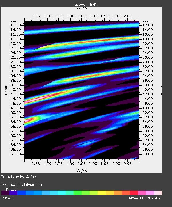
| Estimated Moho Depth: |
53.5 km |
| Estimated Crust Vp/Vs: |
1.60 |
| Assumed Crust Vp: |
6.39 km/s |
| Estimated Crust Vs: |
3.994 km/s |
| Estimated Crust Poisson's Ratio: |
0.18 |
|
| Radial Match: |
96.27484 % |
| Radial Bump: |
281 |
| Transverse Match: |
92.90631 % |
| Transverse Bump: |
400 |
| SOD ConfigId: |
17000 |
| Insert Time: |
2010-02-26 21:58:25.087 +0000 |
| GWidth: |
2.5 |
| Max Bumps: |
400 |
| Tol: |
0.001 |
|
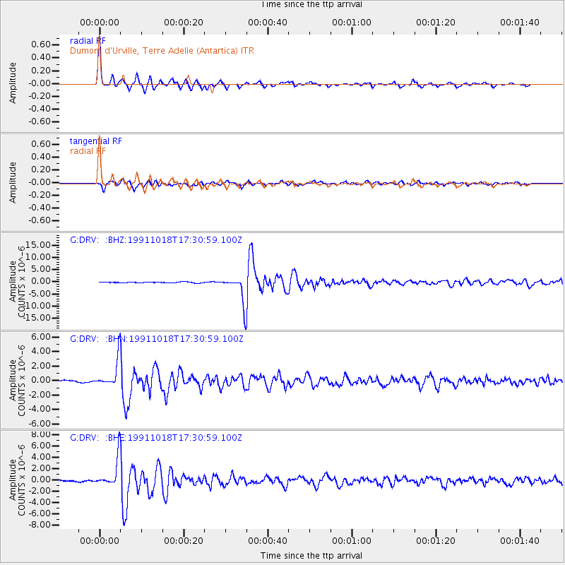
Signal To Noise
| Channel | StoN | STA | LTA |
| G:DRV: :BHN:19911018T17:30:59.100Z | 13.66971 | 1.984662E-6 | 1.4518685E-7 |
| G:DRV: :BHE:19911018T17:30:59.100Z | 27.45346 | 2.702948E-6 | 9.8455644E-8 |
| G:DRV: :BHZ:19911018T17:30:59.100Z | 36.742558 | 6.017436E-6 | 1.6377292E-7 |
| Arrivals |
| Ps | 5.3 SECOND |
| PpPs | 20 SECOND |
| PsPs/PpSs | 26 SECOND |


