You are here: Home > Network List > UW - Pacific Northwest Regional Seismic Network Stations List
> Station STOR Enumclaw, WA, USA > Earthquake Result Viewer
STOR Enumclaw, WA, USA - Earthquake Result Viewer
| Earthquake location: |
Kuril Islands |
| Earthquake latitude/longitude: |
48.8/154.8 |
| Earthquake time(UTC): |
2011/08/04 (216) 13:51:34 GMT |
| Earthquake Depth: |
36 km |
| Earthquake Magnitude: |
6.0 MB, 5.8 MS, 6.1 MW, 6.0 MW |
| Earthquake Catalog/Contributor: |
WHDF/NEIC |
|
| Network: |
UW Pacific Northwest Regional Seismic Network |
| Station: |
STOR Enumclaw, WA, USA |
| Lat/Lon: |
47.19 N/121.99 W |
| Elevation: |
266 m |
|
| Distance: |
53.0 deg |
| Az: |
58.015 deg |
| Baz: |
304.743 deg |
| Ray Param: |
0.066327445 |
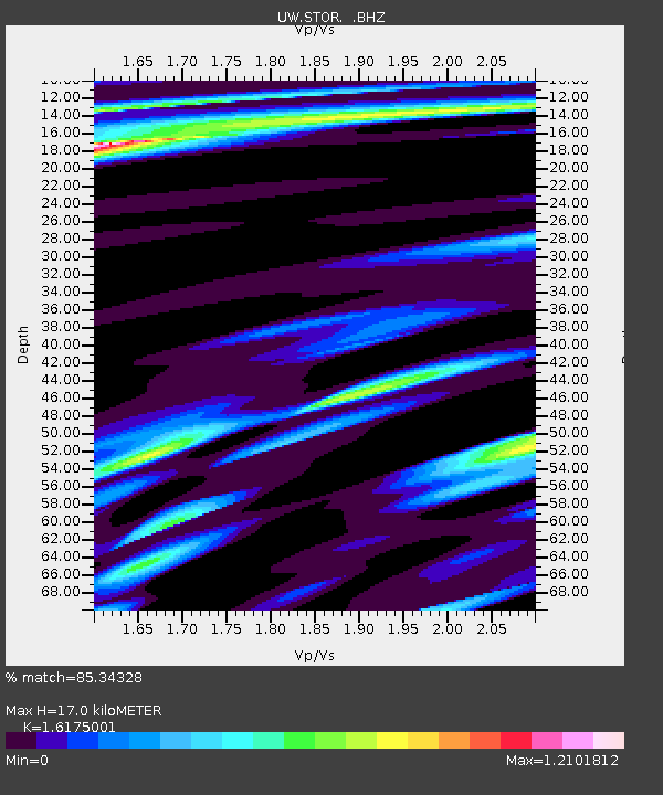
| Estimated Moho Depth: |
17.0 km |
| Estimated Crust Vp/Vs: |
1.62 |
| Assumed Crust Vp: |
6.597 km/s |
| Estimated Crust Vs: |
4.079 km/s |
| Estimated Crust Poisson's Ratio: |
0.19 |
|
| Radial Match: |
85.34328 % |
| Radial Bump: |
400 |
| Transverse Match: |
73.314095 % |
| Transverse Bump: |
400 |
| SOD ConfigId: |
408116 |
| Insert Time: |
2012-01-01 04:50:20.019 +0000 |
| GWidth: |
2.5 |
| Max Bumps: |
400 |
| Tol: |
0.001 |
|

Signal To Noise
| Channel | StoN | STA | LTA |
| UW:STOR: :BHZ:20110804T14:00:17.04999Z | 11.315065 | 1.0623842E-6 | 9.3891124E-8 |
| UW:STOR: :BHN:20110804T14:00:17.04999Z | 3.113071 | 2.607271E-7 | 8.3752376E-8 |
| UW:STOR: :BHE:20110804T14:00:17.04999Z | 5.284493 | 3.8504854E-7 | 7.286386E-8 |
| Arrivals |
| Ps | 1.7 SECOND |
| PpPs | 6.3 SECOND |
| PsPs/PpSs | 8.0 SECOND |


