You are here: Home > Network List > G - GEOSCOPE Stations List
> Station DRV Dumont d'Urville, Terre Adelie (Antartica) > Earthquake Result Viewer
DRV Dumont d'Urville, Terre Adelie (Antartica) - Earthquake Result Viewer
| Earthquake location: |
Flores Region, Indonesia |
| Earthquake latitude/longitude: |
-8.5/121.9 |
| Earthquake time(UTC): |
1992/12/12 (347) 05:29:27 GMT |
| Earthquake Depth: |
35 km |
| Earthquake Magnitude: |
6.7 MB, 7.5 MS, 7.5 UNKNOWN |
| Earthquake Catalog/Contributor: |
WHDF/NEIC |
|
| Network: |
G GEOSCOPE |
| Station: |
DRV Dumont d'Urville, Terre Adelie (Antartica) |
| Lat/Lon: |
66.67 S/140.01 E |
| Elevation: |
40 m |
|
| Distance: |
59.4 deg |
| Az: |
171.723 deg |
| Baz: |
339.056 deg |
| Ray Param: |
0.062164728 |
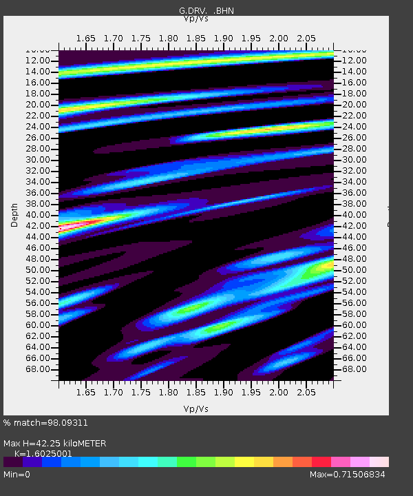
| Estimated Moho Depth: |
42.25 km |
| Estimated Crust Vp/Vs: |
1.60 |
| Assumed Crust Vp: |
6.39 km/s |
| Estimated Crust Vs: |
3.987 km/s |
| Estimated Crust Poisson's Ratio: |
0.18 |
|
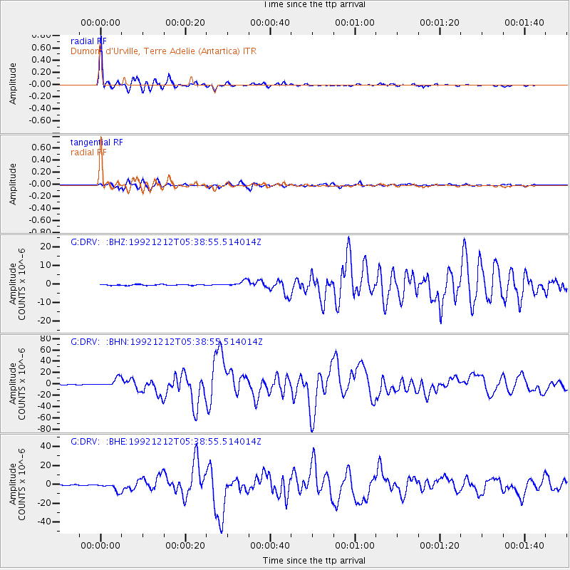
| Radial Match: |
98.09311 % |
| Radial Bump: |
369 |
| Transverse Match: |
95.58647 % |
| Transverse Bump: |
400 |
| SOD ConfigId: |
4480 |
| Insert Time: |
2010-02-26 21:58:38.702 +0000 |
| GWidth: |
2.5 |
| Max Bumps: |
400 |
| Tol: |
0.001 |
|
Signal To Noise
| Channel | StoN | STA | LTA |
| G:DRV: :BHN:19921212T05:38:55.514014Z | 24.87513 | 8.081508E-6 | 3.2488305E-7 |
| G:DRV: :BHE:19921212T05:38:55.514014Z | 15.133274 | 4.5320267E-6 | 2.994743E-7 |
| G:DRV: :BHZ:19921212T05:38:55.514014Z | 6.6269636 | 1.6039613E-6 | 2.4203564E-7 |
| Arrivals |
| Ps | 4.2 SECOND |
| PpPs | 16 SECOND |
| PsPs/PpSs | 21 SECOND |


