You are here: Home > Network List > TA - USArray Transportable Network (new EarthScope stations) Stations List
> Station Y12C Blythe, CA, USA > Earthquake Result Viewer
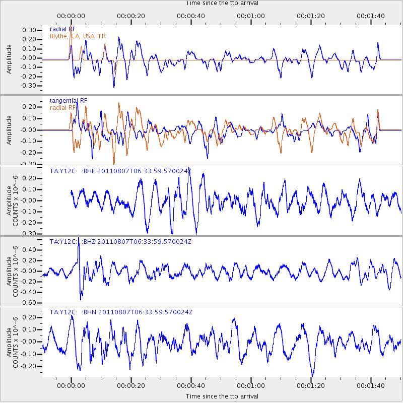
Y12C Blythe, CA, USA - Earthquake Result Viewer
*The percent match for this event was below the threshold and hence no stack was calculated.
| Earthquake location: |
Santa Cruz Islands Region |
| Earthquake latitude/longitude: |
-11.8/168.3 |
| Earthquake time(UTC): |
2011/08/07 (219) 06:22:34 GMT |
| Earthquake Depth: |
403 km |
| Earthquake Magnitude: |
5.7 MB, 5.7 MW, 5.7 MW |
| Earthquake Catalog/Contributor: |
WHDF/NEIC |
|
| Network: |
TA USArray Transportable Network (new EarthScope stations) |
| Station: |
Y12C Blythe, CA, USA |
| Lat/Lon: |
33.75 N/114.52 W |
| Elevation: |
196 m |
|
| Distance: |
86.0 deg |
| Az: |
54.519 deg |
| Baz: |
253.136 deg |
| Ray Param: |
$rayparam |
*The percent match for this event was below the threshold and hence was not used in the summary stack. |
|
| Radial Match: |
64.850204 % |
| Radial Bump: |
400 |
| Transverse Match: |
63.231655 % |
| Transverse Bump: |
400 |
| SOD ConfigId: |
410809 |
| Insert Time: |
2012-01-04 00:58:23.605 +0000 |
| GWidth: |
2.5 |
| Max Bumps: |
400 |
| Tol: |
0.001 |
|
Signal To Noise
| Channel | StoN | STA | LTA |
| TA:Y12C: :BHZ:20110807T06:33:59.570024Z | 3.812129 | 2.596767E-7 | 6.811855E-8 |
| TA:Y12C: :BHN:20110807T06:33:59.570024Z | 2.3188903 | 1.444071E-7 | 6.2274225E-8 |
| TA:Y12C: :BHE:20110807T06:33:59.570024Z | 1.7280333 | 1.2520111E-7 | 7.245295E-8 |
| Arrivals |
| Ps | |
| PpPs | |
| PsPs/PpSs | |


