You are here: Home > Network List > US - United States National Seismic Network Stations List
> Station ELK Elko, Nevada, USA > Earthquake Result Viewer
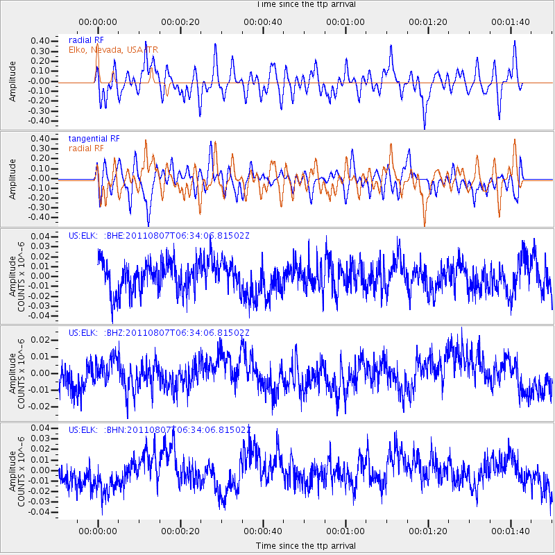
ELK Elko, Nevada, USA - Earthquake Result Viewer
*The percent match for this event was below the threshold and hence no stack was calculated.
| Earthquake location: |
Santa Cruz Islands Region |
| Earthquake latitude/longitude: |
-11.8/168.3 |
| Earthquake time(UTC): |
2011/08/07 (219) 06:22:34 GMT |
| Earthquake Depth: |
403 km |
| Earthquake Magnitude: |
5.7 MB, 5.7 MW, 5.7 MW |
| Earthquake Catalog/Contributor: |
WHDF/NEIC |
|
| Network: |
US United States National Seismic Network |
| Station: |
ELK Elko, Nevada, USA |
| Lat/Lon: |
40.74 N/115.24 W |
| Elevation: |
2210 m |
|
| Distance: |
87.6 deg |
| Az: |
47.673 deg |
| Baz: |
252.323 deg |
| Ray Param: |
$rayparam |
*The percent match for this event was below the threshold and hence was not used in the summary stack. |
|
| Radial Match: |
49.020073 % |
| Radial Bump: |
400 |
| Transverse Match: |
41.697247 % |
| Transverse Bump: |
400 |
| SOD ConfigId: |
410809 |
| Insert Time: |
2012-01-04 01:00:49.649 +0000 |
| GWidth: |
2.5 |
| Max Bumps: |
400 |
| Tol: |
0.001 |
|
Signal To Noise
| Channel | StoN | STA | LTA |
| US:ELK: :BHZ:20110807T06:34:06.81502Z | 0.73178387 | 6.6963737E-9 | 9.150753E-9 |
| US:ELK: :BHN:20110807T06:34:06.81502Z | 1.3744439 | 2.0660567E-8 | 1.5031947E-8 |
| US:ELK: :BHE:20110807T06:34:06.81502Z | 0.8363276 | 1.2914044E-8 | 1.544137E-8 |
| Arrivals |
| Ps | |
| PpPs | |
| PsPs/PpSs | |


