You are here: Home > Network List > G - GEOSCOPE Stations List
> Station DRV Dumont d'Urville, Terre Adelie (Antartica) > Earthquake Result Viewer
DRV Dumont d'Urville, Terre Adelie (Antartica) - Earthquake Result Viewer
| Earthquake location: |
Vanuatu Islands |
| Earthquake latitude/longitude: |
-19.3/168.9 |
| Earthquake time(UTC): |
1992/10/11 (285) 19:24:29 GMT |
| Earthquake Depth: |
157 km |
| Earthquake Magnitude: |
6.4 MB |
| Earthquake Catalog/Contributor: |
WHDF/NEIC |
|
| Network: |
G GEOSCOPE |
| Station: |
DRV Dumont d'Urville, Terre Adelie (Antartica) |
| Lat/Lon: |
66.67 S/140.01 E |
| Elevation: |
40 m |
|
| Distance: |
50.9 deg |
| Az: |
194.361 deg |
| Baz: |
36.026 deg |
| Ray Param: |
0.06720389 |
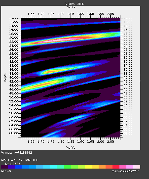
| Estimated Moho Depth: |
21.25 km |
| Estimated Crust Vp/Vs: |
1.76 |
| Assumed Crust Vp: |
6.39 km/s |
| Estimated Crust Vs: |
3.636 km/s |
| Estimated Crust Poisson's Ratio: |
0.26 |
|
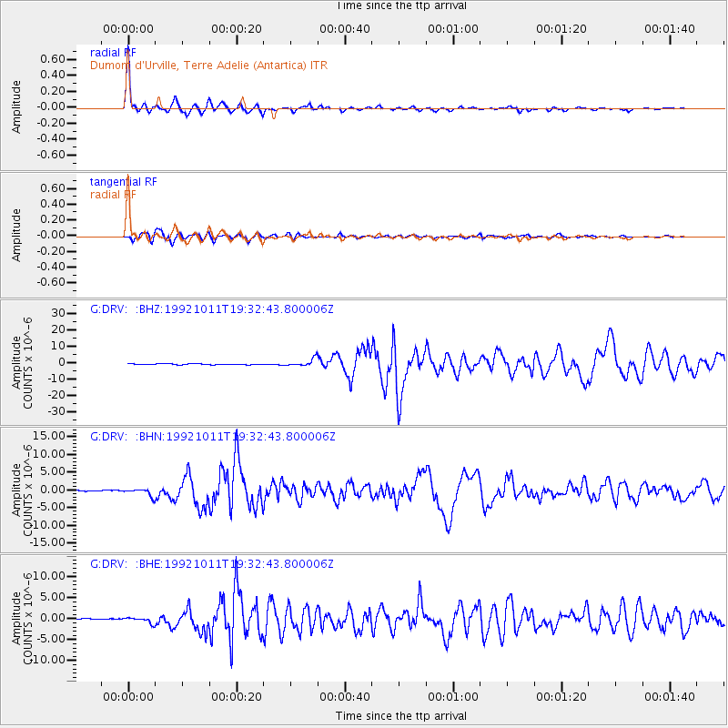
| Radial Match: |
98.24842 % |
| Radial Bump: |
330 |
| Transverse Match: |
92.50642 % |
| Transverse Bump: |
400 |
| SOD ConfigId: |
16938 |
| Insert Time: |
2010-02-26 21:59:09.683 +0000 |
| GWidth: |
2.5 |
| Max Bumps: |
400 |
| Tol: |
0.001 |
|
Signal To Noise
| Channel | StoN | STA | LTA |
| G:DRV: :BHN:19921011T19:32:43.800006Z | 4.6052237 | 1.0549201E-6 | 2.2907034E-7 |
| G:DRV: :BHE:19921011T19:32:43.800006Z | 3.8190305 | 6.781254E-7 | 1.775648E-7 |
| G:DRV: :BHZ:19921011T19:32:43.800006Z | 8.391381 | 2.3013433E-6 | 2.7425082E-7 |
| Arrivals |
| Ps | 2.7 SECOND |
| PpPs | 8.7 SECOND |
| PsPs/PpSs | 11 SECOND |


