You are here: Home > Network List > G - GEOSCOPE Stations List
> Station DRV Dumont d'Urville, Terre Adelie (Antartica) > Earthquake Result Viewer
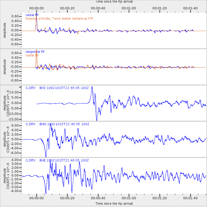
DRV Dumont d'Urville, Terre Adelie (Antartica) - Earthquake Result Viewer

| Earthquake location: |
Vanuatu Islands |
| Earthquake latitude/longitude: |
-14.5/166.6 |
| Earthquake time(UTC): |
1992/10/15 (289) 22:37:07 GMT |
| Earthquake Depth: |
33 km |
| Earthquake Magnitude: |
6.1 MB, 6.8 MS, 7.1 UNKNOWN |
| Earthquake Catalog/Contributor: |
WHDF/NEIC |
|
| Network: |
G GEOSCOPE |
| Station: |
DRV Dumont d'Urville, Terre Adelie (Antartica) |
| Lat/Lon: |
66.67 S/140.01 E |
| Elevation: |
40 m |
|
| Distance: |
55.1 deg |
| Az: |
192.573 deg |
| Baz: |
31.964 deg |
| Ray Param: |
0.06497355 |
| Estimated Moho Depth: |
20.5 km |
| Estimated Crust Vp/Vs: |
1.81 |
| Assumed Crust Vp: |
6.39 km/s |
| Estimated Crust Vs: |
3.525 km/s |
| Estimated Crust Poisson's Ratio: |
0.28 |
|
| Radial Match: |
97.13796 % |
| Radial Bump: |
343 |
| Transverse Match: |
89.90001 % |
| Transverse Bump: |
400 |
| SOD ConfigId: |
16938 |
| Insert Time: |
2010-02-26 21:59:10.926 +0000 |
| GWidth: |
2.5 |
| Max Bumps: |
400 |
| Tol: |
0.001 |
|
Signal To Noise
| Channel | StoN | STA | LTA |
| G:DRV: :BHN:19921015T22:46:05.100Z | 3.9778914 | 6.671253E-7 | 1.6770827E-7 |
| G:DRV: :BHE:19921015T22:46:05.100Z | 1.278168 | 2.5498804E-7 | 1.9949492E-7 |
| G:DRV: :BHZ:19921015T22:46:05.100Z | 2.686302 | 8.9600246E-7 | 3.3354496E-7 |
| Arrivals |
| Ps | 2.7 SECOND |
| PpPs | 8.6 SECOND |
| PsPs/PpSs | 11 SECOND |


