You are here: Home > Network List > TA - USArray Transportable Network (new EarthScope stations) Stations List
> Station 138A Matatall Enterprise, Big Sandy, TX, USA > Earthquake Result Viewer
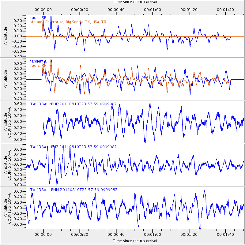
138A Matatall Enterprise, Big Sandy, TX, USA - Earthquake Result Viewer
*The percent match for this event was below the threshold and hence no stack was calculated.
| Earthquake location: |
Ascension Island Region |
| Earthquake latitude/longitude: |
-7.0/-12.6 |
| Earthquake time(UTC): |
2011/08/10 (222) 23:45:43 GMT |
| Earthquake Depth: |
10 km |
| Earthquake Magnitude: |
5.5 MB, 5.5 MS, 6.0 MW, 5.8 MW |
| Earthquake Catalog/Contributor: |
WHDF/NEIC |
|
| Network: |
TA USArray Transportable Network (new EarthScope stations) |
| Station: |
138A Matatall Enterprise, Big Sandy, TX, USA |
| Lat/Lon: |
32.66 N/95.09 W |
| Elevation: |
143 m |
|
| Distance: |
87.5 deg |
| Az: |
303.168 deg |
| Baz: |
99.946 deg |
| Ray Param: |
$rayparam |
*The percent match for this event was below the threshold and hence was not used in the summary stack. |
|
| Radial Match: |
63.552124 % |
| Radial Bump: |
387 |
| Transverse Match: |
65.46312 % |
| Transverse Bump: |
400 |
| SOD ConfigId: |
410809 |
| Insert Time: |
2012-01-04 01:17:47.692 +0000 |
| GWidth: |
2.5 |
| Max Bumps: |
400 |
| Tol: |
0.001 |
|
Signal To Noise
| Channel | StoN | STA | LTA |
| TA:138A: :BHZ:20110810T23:57:59.099998Z | 2.2861724 | 3.5564062E-7 | 1.555616E-7 |
| TA:138A: :BHN:20110810T23:57:59.099998Z | 0.7199059 | 1.63048E-7 | 2.2648514E-7 |
| TA:138A: :BHE:20110810T23:57:59.099998Z | 0.94275385 | 1.9093339E-7 | 2.0252729E-7 |
| Arrivals |
| Ps | |
| PpPs | |
| PsPs/PpSs | |


