You are here: Home > Network List > TA - USArray Transportable Network (new EarthScope stations) Stations List
> Station T40A Mansfield, MO, USA > Earthquake Result Viewer
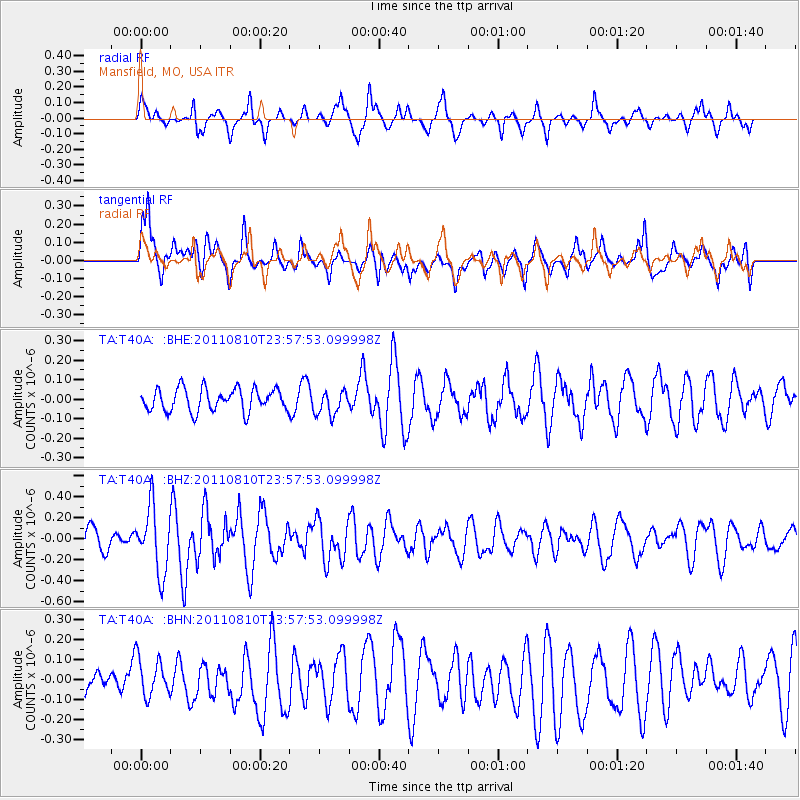
T40A Mansfield, MO, USA - Earthquake Result Viewer
*The percent match for this event was below the threshold and hence no stack was calculated.
| Earthquake location: |
Ascension Island Region |
| Earthquake latitude/longitude: |
-7.0/-12.6 |
| Earthquake time(UTC): |
2011/08/10 (222) 23:45:43 GMT |
| Earthquake Depth: |
10 km |
| Earthquake Magnitude: |
5.5 MB, 5.5 MS, 6.0 MW, 5.8 MW |
| Earthquake Catalog/Contributor: |
WHDF/NEIC |
|
| Network: |
TA USArray Transportable Network (new EarthScope stations) |
| Station: |
T40A Mansfield, MO, USA |
| Lat/Lon: |
37.15 N/92.52 W |
| Elevation: |
399 m |
|
| Distance: |
86.2 deg |
| Az: |
307.97 deg |
| Baz: |
101.676 deg |
| Ray Param: |
$rayparam |
*The percent match for this event was below the threshold and hence was not used in the summary stack. |
|
| Radial Match: |
69.93903 % |
| Radial Bump: |
308 |
| Transverse Match: |
71.45176 % |
| Transverse Bump: |
400 |
| SOD ConfigId: |
410809 |
| Insert Time: |
2012-01-04 01:19:39.900 +0000 |
| GWidth: |
2.5 |
| Max Bumps: |
400 |
| Tol: |
0.001 |
|
Signal To Noise
| Channel | StoN | STA | LTA |
| TA:T40A: :BHZ:20110810T23:57:53.099998Z | 2.94743 | 3.1086765E-7 | 1.05470754E-7 |
| TA:T40A: :BHN:20110810T23:57:53.099998Z | 1.1295844 | 9.878113E-8 | 8.7449095E-8 |
| TA:T40A: :BHE:20110810T23:57:53.099998Z | 1.0994471 | 6.3526414E-8 | 5.7780326E-8 |
| Arrivals |
| Ps | |
| PpPs | |
| PsPs/PpSs | |


