You are here: Home > Network List > G - GEOSCOPE Stations List
> Station DRV Dumont d'Urville, Terre Adelie (Antartica) > Earthquake Result Viewer
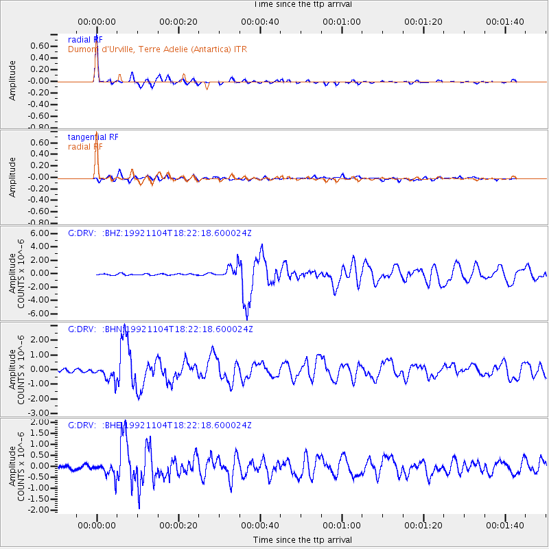
DRV Dumont d'Urville, Terre Adelie (Antartica) - Earthquake Result Viewer
| Earthquake location: |
Vanuatu Islands |
| Earthquake latitude/longitude: |
-14.2/167.5 |
| Earthquake time(UTC): |
1992/11/04 (309) 18:13:17 GMT |
| Earthquake Depth: |
33 km |
| Earthquake Magnitude: |
6.0 MB, 6.2 MS |
| Earthquake Catalog/Contributor: |
WHDF/NEIC |
|
| Network: |
G GEOSCOPE |
| Station: |
DRV Dumont d'Urville, Terre Adelie (Antartica) |
| Lat/Lon: |
66.67 S/140.01 E |
| Elevation: |
40 m |
|
| Distance: |
55.5 deg |
| Az: |
192.882 deg |
| Baz: |
32.879 deg |
| Ray Param: |
0.064662 |
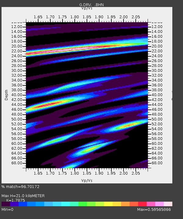
| Estimated Moho Depth: |
21.0 km |
| Estimated Crust Vp/Vs: |
1.79 |
| Assumed Crust Vp: |
6.39 km/s |
| Estimated Crust Vs: |
3.575 km/s |
| Estimated Crust Poisson's Ratio: |
0.27 |
|
| Radial Match: |
96.70172 % |
| Radial Bump: |
239 |
| Transverse Match: |
73.27935 % |
| Transverse Bump: |
400 |
| SOD ConfigId: |
16938 |
| Insert Time: |
2010-02-26 21:59:18.903 +0000 |
| GWidth: |
2.5 |
| Max Bumps: |
400 |
| Tol: |
0.001 |
|
Signal To Noise
| Channel | StoN | STA | LTA |
| G:DRV: :BHN:19921104T18:22:18.600024Z | 3.4524217 | 4.744348E-7 | 1.3742088E-7 |
| G:DRV: :BHE:19921104T18:22:18.600024Z | 2.999799 | 3.527949E-7 | 1.1760618E-7 |
| G:DRV: :BHZ:19921104T18:22:18.600024Z | 10.06474 | 9.86685E-7 | 9.8033816E-8 |
| Arrivals |
| Ps | 2.7 SECOND |
| PpPs | 8.7 SECOND |
| PsPs/PpSs | 11 SECOND |


