You are here: Home > Network List > CN - Canadian National Seismograph Network Stations List
> Station FRB Iqaluit, Nunavut Territory, Canada > Earthquake Result Viewer
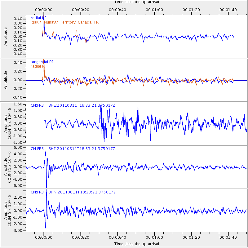
FRB Iqaluit, Nunavut Territory, Canada - Earthquake Result Viewer
*The percent match for this event was below the threshold and hence no stack was calculated.
| Earthquake location: |
Eastern Honshu, Japan |
| Earthquake latitude/longitude: |
37.0/140.9 |
| Earthquake time(UTC): |
2011/08/11 (223) 18:22:04 GMT |
| Earthquake Depth: |
44 km |
| Earthquake Magnitude: |
6.0 MB, 5.3 MS, 5.9 MW, 5.9 MW |
| Earthquake Catalog/Contributor: |
WHDF/NEIC |
|
| Network: |
CN Canadian National Seismograph Network |
| Station: |
FRB Iqaluit, Nunavut Territory, Canada |
| Lat/Lon: |
63.75 N/68.55 W |
| Elevation: |
25 m |
|
| Distance: |
76.9 deg |
| Az: |
12.97 deg |
| Baz: |
336.181 deg |
| Ray Param: |
$rayparam |
*The percent match for this event was below the threshold and hence was not used in the summary stack. |
|
| Radial Match: |
62.07118 % |
| Radial Bump: |
400 |
| Transverse Match: |
58.120724 % |
| Transverse Bump: |
400 |
| SOD ConfigId: |
410809 |
| Insert Time: |
2012-01-04 01:36:02.629 +0000 |
| GWidth: |
2.5 |
| Max Bumps: |
400 |
| Tol: |
0.001 |
|
Signal To Noise
| Channel | StoN | STA | LTA |
| CN:FRB: :BHZ:20110811T18:33:21.375017Z | 9.330062 | 2.2163201E-6 | 2.3754615E-7 |
| CN:FRB: :BHN:20110811T18:33:21.375017Z | 6.4926724 | 1.0515726E-6 | 1.6196297E-7 |
| CN:FRB: :BHE:20110811T18:33:21.375017Z | 3.941116 | 7.4978243E-7 | 1.9024623E-7 |
| Arrivals |
| Ps | |
| PpPs | |
| PsPs/PpSs | |


