You are here: Home > Network List > MN - MEDNET Project Stations List
> Station TIP Timpagrande, Italy > Earthquake Result Viewer
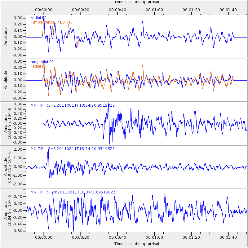
TIP Timpagrande, Italy - Earthquake Result Viewer
*The percent match for this event was below the threshold and hence no stack was calculated.
| Earthquake location: |
Eastern Honshu, Japan |
| Earthquake latitude/longitude: |
37.0/140.9 |
| Earthquake time(UTC): |
2011/08/11 (223) 18:22:04 GMT |
| Earthquake Depth: |
44 km |
| Earthquake Magnitude: |
6.0 MB, 5.3 MS, 5.9 MW, 5.9 MW |
| Earthquake Catalog/Contributor: |
WHDF/NEIC |
|
| Network: |
MN MEDNET Project |
| Station: |
TIP Timpagrande, Italy |
| Lat/Lon: |
39.18 N/16.76 E |
| Elevation: |
789 m |
|
| Distance: |
88.4 deg |
| Az: |
319.939 deg |
| Baz: |
41.5 deg |
| Ray Param: |
$rayparam |
*The percent match for this event was below the threshold and hence was not used in the summary stack. |
|
| Radial Match: |
75.68668 % |
| Radial Bump: |
400 |
| Transverse Match: |
72.00565 % |
| Transverse Bump: |
400 |
| SOD ConfigId: |
410809 |
| Insert Time: |
2012-01-04 01:42:23.608 +0000 |
| GWidth: |
2.5 |
| Max Bumps: |
400 |
| Tol: |
0.001 |
|
Signal To Noise
| Channel | StoN | STA | LTA |
| MN:TIP: :BHZ:20110811T18:34:20.951982Z | 7.6248217 | 8.358931E-7 | 1.0962789E-7 |
| MN:TIP: :BHN:20110811T18:34:20.951982Z | 2.0194738 | 2.2354072E-7 | 1.1069256E-7 |
| MN:TIP: :BHE:20110811T18:34:20.951982Z | 3.050997 | 2.5581676E-7 | 8.384694E-8 |
| Arrivals |
| Ps | |
| PpPs | |
| PsPs/PpSs | |


