You are here: Home > Network List > TA - USArray Transportable Network (new EarthScope stations) Stations List
> Station I04A Tendick Farm, Oakridge, OR, USA > Earthquake Result Viewer
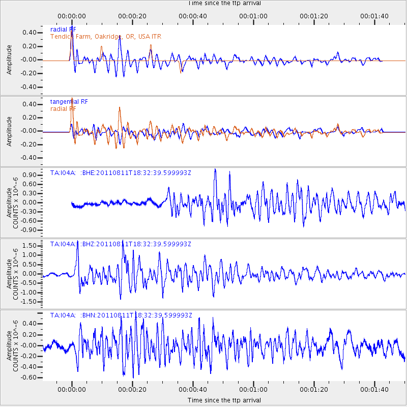
I04A Tendick Farm, Oakridge, OR, USA - Earthquake Result Viewer

| Earthquake location: |
Eastern Honshu, Japan |
| Earthquake latitude/longitude: |
37.0/140.9 |
| Earthquake time(UTC): |
2011/08/11 (223) 18:22:04 GMT |
| Earthquake Depth: |
44 km |
| Earthquake Magnitude: |
6.0 MB, 5.3 MS, 5.9 MW, 5.9 MW |
| Earthquake Catalog/Contributor: |
WHDF/NEIC |
|
| Network: |
TA USArray Transportable Network (new EarthScope stations) |
| Station: |
I04A Tendick Farm, Oakridge, OR, USA |
| Lat/Lon: |
43.79 N/122.41 W |
| Elevation: |
731 m |
|
| Distance: |
69.8 deg |
| Az: |
50.046 deg |
| Baz: |
302.104 deg |
| Ray Param: |
0.05535315 |
| Estimated Moho Depth: |
41.0 km |
| Estimated Crust Vp/Vs: |
1.62 |
| Assumed Crust Vp: |
6.522 km/s |
| Estimated Crust Vs: |
4.013 km/s |
| Estimated Crust Poisson's Ratio: |
0.20 |
|
| Radial Match: |
93.20477 % |
| Radial Bump: |
400 |
| Transverse Match: |
78.37021 % |
| Transverse Bump: |
400 |
| SOD ConfigId: |
410809 |
| Insert Time: |
2012-01-04 01:45:51.583 +0000 |
| GWidth: |
2.5 |
| Max Bumps: |
400 |
| Tol: |
0.001 |
|
Signal To Noise
| Channel | StoN | STA | LTA |
| TA:I04A: :BHZ:20110811T18:32:39.599993Z | 11.210011 | 6.3178834E-7 | 5.6359294E-8 |
| TA:I04A: :BHN:20110811T18:32:39.599993Z | 3.1254764 | 2.0208275E-7 | 6.4656625E-8 |
| TA:I04A: :BHE:20110811T18:32:39.599993Z | 4.4105372 | 2.3897093E-7 | 5.4181818E-8 |
| Arrivals |
| Ps | 4.1 SECOND |
| PpPs | 16 SECOND |
| PsPs/PpSs | 20 SECOND |


