You are here: Home > Network List > G - GEOSCOPE Stations List
> Station DRV Dumont d'Urville, Terre Adelie (Antartica) > Earthquake Result Viewer
DRV Dumont d'Urville, Terre Adelie (Antartica) - Earthquake Result Viewer
| Earthquake location: |
South Of Mariana Islands |
| Earthquake latitude/longitude: |
13.0/144.8 |
| Earthquake time(UTC): |
1993/08/08 (220) 08:34:25 GMT |
| Earthquake Depth: |
61 km |
| Earthquake Magnitude: |
7.2 MB, 8.1 MS, 8.2 UNKNOWN, 7.5 MW |
| Earthquake Catalog/Contributor: |
WHDF/NEIC |
|
| Network: |
G GEOSCOPE |
| Station: |
DRV Dumont d'Urville, Terre Adelie (Antartica) |
| Lat/Lon: |
66.67 S/140.01 E |
| Elevation: |
40 m |
|
| Distance: |
79.5 deg |
| Az: |
181.929 deg |
| Baz: |
4.725 deg |
| Ray Param: |
0.04881087 |
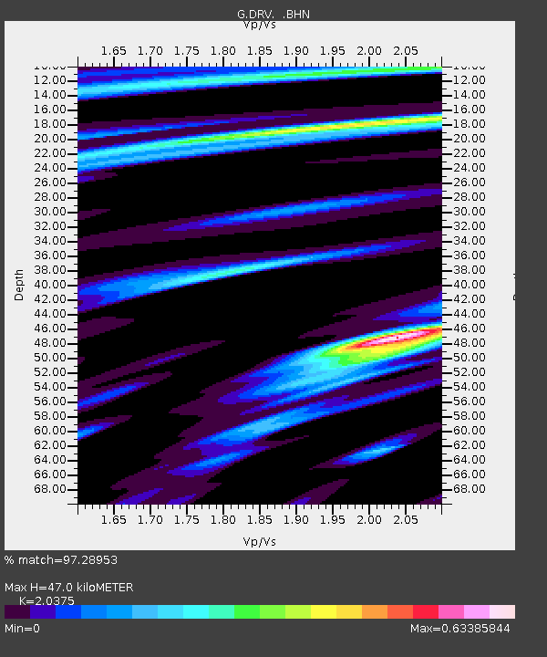
| Estimated Moho Depth: |
47.0 km |
| Estimated Crust Vp/Vs: |
2.04 |
| Assumed Crust Vp: |
6.39 km/s |
| Estimated Crust Vs: |
3.136 km/s |
| Estimated Crust Poisson's Ratio: |
0.34 |
|
| Radial Match: |
97.28953 % |
| Radial Bump: |
355 |
| Transverse Match: |
91.351425 % |
| Transverse Bump: |
400 |
| SOD ConfigId: |
4480 |
| Insert Time: |
2010-02-26 21:59:47.597 +0000 |
| GWidth: |
2.5 |
| Max Bumps: |
400 |
| Tol: |
0.001 |
|
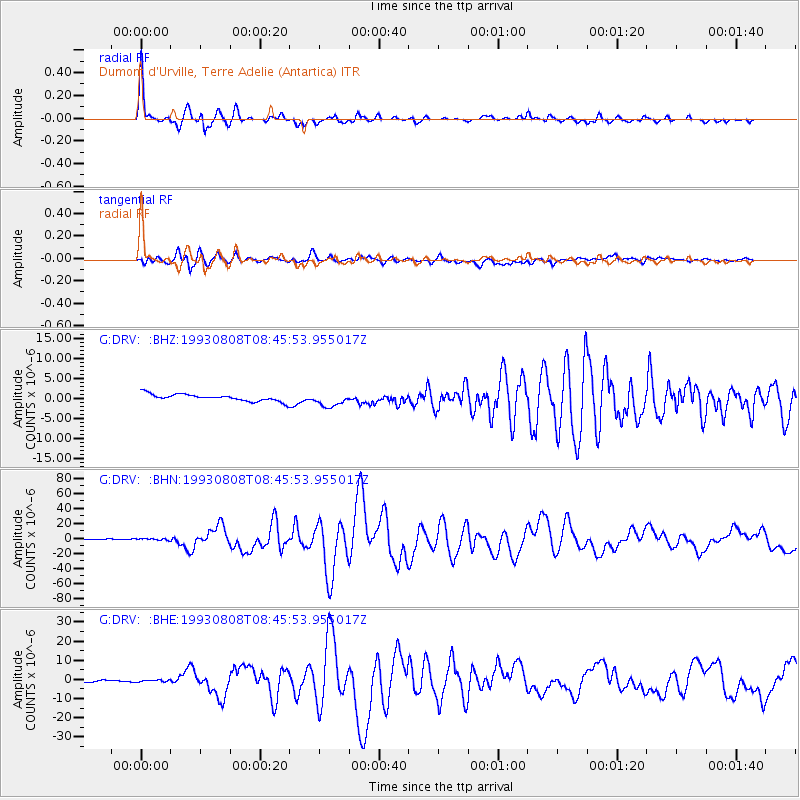
Signal To Noise
| Channel | StoN | STA | LTA |
| G:DRV: :BHN:19930808T08:45:53.955017Z | 2.3604333 | 1.186032E-6 | 5.024637E-7 |
| G:DRV: :BHE:19930808T08:45:53.955017Z | 1.4546976 | 6.4886007E-7 | 4.4604465E-7 |
| G:DRV: :BHZ:19930808T08:45:53.955017Z | 2.0117211 | 1.7164248E-6 | 8.5321216E-7 |
| Arrivals |
| Ps | 7.8 SECOND |
| PpPs | 22 SECOND |
| PsPs/PpSs | 30 SECOND |


