You are here: Home > Network List > TA - USArray Transportable Network (new EarthScope stations) Stations List
> Station X33A Lawton, OK, USA > Earthquake Result Viewer
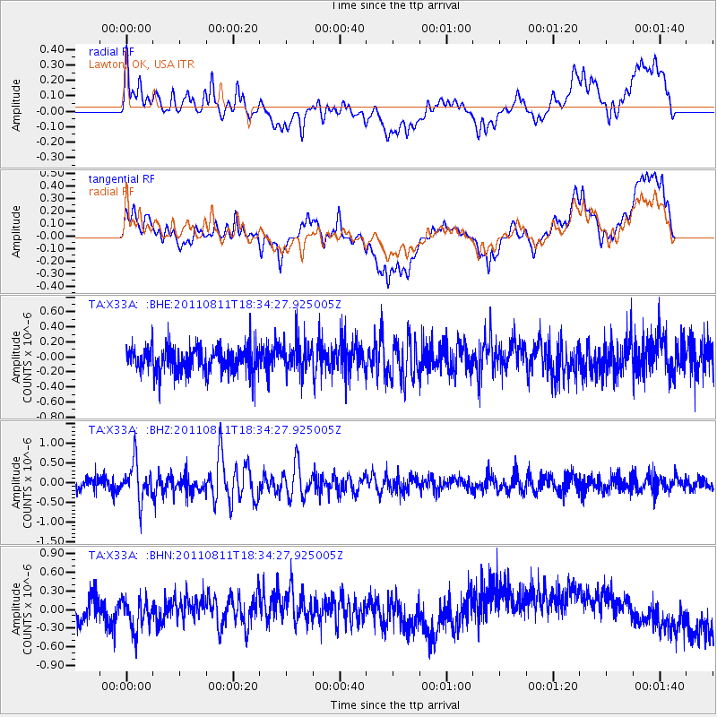
X33A Lawton, OK, USA - Earthquake Result Viewer
*The percent match for this event was below the threshold and hence no stack was calculated.
| Earthquake location: |
Eastern Honshu, Japan |
| Earthquake latitude/longitude: |
37.0/140.9 |
| Earthquake time(UTC): |
2011/08/11 (223) 18:22:04 GMT |
| Earthquake Depth: |
44 km |
| Earthquake Magnitude: |
6.0 MB, 5.3 MS, 5.9 MW, 5.9 MW |
| Earthquake Catalog/Contributor: |
WHDF/NEIC |
|
| Network: |
TA USArray Transportable Network (new EarthScope stations) |
| Station: |
X33A Lawton, OK, USA |
| Lat/Lon: |
34.54 N/98.50 W |
| Elevation: |
346 m |
|
| Distance: |
89.9 deg |
| Az: |
45.275 deg |
| Baz: |
316.47 deg |
| Ray Param: |
$rayparam |
*The percent match for this event was below the threshold and hence was not used in the summary stack. |
|
| Radial Match: |
30.100405 % |
| Radial Bump: |
400 |
| Transverse Match: |
32.49164 % |
| Transverse Bump: |
400 |
| SOD ConfigId: |
410809 |
| Insert Time: |
2012-01-04 01:49:58.640 +0000 |
| GWidth: |
2.5 |
| Max Bumps: |
400 |
| Tol: |
0.001 |
|
Signal To Noise
| Channel | StoN | STA | LTA |
| TA:X33A: :BHZ:20110811T18:34:27.925005Z | 3.6884944 | 4.7705913E-7 | 1.293371E-7 |
| TA:X33A: :BHN:20110811T18:34:27.925005Z | 0.94337744 | 2.4077534E-7 | 2.5522692E-7 |
| TA:X33A: :BHE:20110811T18:34:27.925005Z | 1.2348164 | 2.0511273E-7 | 1.6610787E-7 |
| Arrivals |
| Ps | |
| PpPs | |
| PsPs/PpSs | |


