You are here: Home > Network List > TA - USArray Transportable Network (new EarthScope stations) Stations List
> Station 334A Lometa, TX, USA > Earthquake Result Viewer
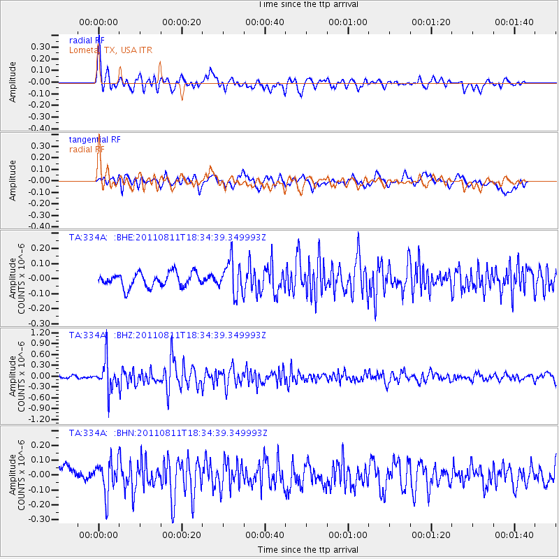
334A Lometa, TX, USA - Earthquake Result Viewer
*The percent match for this event was below the threshold and hence no stack was calculated.
| Earthquake location: |
Eastern Honshu, Japan |
| Earthquake latitude/longitude: |
37.0/140.9 |
| Earthquake time(UTC): |
2011/08/11 (223) 18:22:04 GMT |
| Earthquake Depth: |
44 km |
| Earthquake Magnitude: |
6.0 MB, 5.3 MS, 5.9 MW, 5.9 MW |
| Earthquake Catalog/Contributor: |
WHDF/NEIC |
|
| Network: |
TA USArray Transportable Network (new EarthScope stations) |
| Station: |
334A Lometa, TX, USA |
| Lat/Lon: |
31.33 N/98.24 W |
| Elevation: |
389 m |
|
| Distance: |
92.4 deg |
| Az: |
47.316 deg |
| Baz: |
316.572 deg |
| Ray Param: |
$rayparam |
*The percent match for this event was below the threshold and hence was not used in the summary stack. |
|
| Radial Match: |
74.31447 % |
| Radial Bump: |
400 |
| Transverse Match: |
66.04117 % |
| Transverse Bump: |
400 |
| SOD ConfigId: |
410809 |
| Insert Time: |
2012-01-04 01:52:22.387 +0000 |
| GWidth: |
2.5 |
| Max Bumps: |
400 |
| Tol: |
0.001 |
|
Signal To Noise
| Channel | StoN | STA | LTA |
| TA:334A: :BHZ:20110811T18:34:39.349993Z | 7.2720113 | 4.334584E-7 | 5.96064E-8 |
| TA:334A: :BHN:20110811T18:34:39.349993Z | 2.6408722 | 1.1309748E-7 | 4.2825803E-8 |
| TA:334A: :BHE:20110811T18:34:39.349993Z | 2.4490325 | 1.14041526E-7 | 4.6565948E-8 |
| Arrivals |
| Ps | |
| PpPs | |
| PsPs/PpSs | |


