You are here: Home > Network List > TA - USArray Transportable Network (new EarthScope stations) Stations List
> Station T34A McClaskey Farms, Geuda Springs, KS, USA > Earthquake Result Viewer
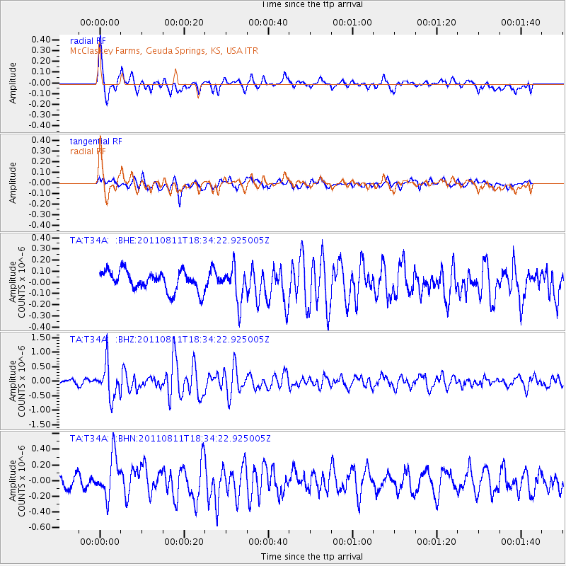
T34A McClaskey Farms, Geuda Springs, KS, USA - Earthquake Result Viewer
*The percent match for this event was below the threshold and hence no stack was calculated.
| Earthquake location: |
Eastern Honshu, Japan |
| Earthquake latitude/longitude: |
37.0/140.9 |
| Earthquake time(UTC): |
2011/08/11 (223) 18:22:04 GMT |
| Earthquake Depth: |
44 km |
| Earthquake Magnitude: |
6.0 MB, 5.3 MS, 5.9 MW, 5.9 MW |
| Earthquake Catalog/Contributor: |
WHDF/NEIC |
|
| Network: |
TA USArray Transportable Network (new EarthScope stations) |
| Station: |
T34A McClaskey Farms, Geuda Springs, KS, USA |
| Lat/Lon: |
37.02 N/97.19 W |
| Elevation: |
361 m |
|
| Distance: |
88.8 deg |
| Az: |
42.803 deg |
| Baz: |
317.205 deg |
| Ray Param: |
$rayparam |
*The percent match for this event was below the threshold and hence was not used in the summary stack. |
|
| Radial Match: |
72.58639 % |
| Radial Bump: |
400 |
| Transverse Match: |
68.63754 % |
| Transverse Bump: |
400 |
| SOD ConfigId: |
410809 |
| Insert Time: |
2012-01-04 01:57:23.965 +0000 |
| GWidth: |
2.5 |
| Max Bumps: |
400 |
| Tol: |
0.001 |
|
Signal To Noise
| Channel | StoN | STA | LTA |
| TA:T34A: :BHZ:20110811T18:34:22.925005Z | 7.697864 | 5.922241E-7 | 7.693357E-8 |
| TA:T34A: :BHN:20110811T18:34:22.925005Z | 4.1664014 | 2.661548E-7 | 6.3881224E-8 |
| TA:T34A: :BHE:20110811T18:34:22.925005Z | 1.7717264 | 1.5542614E-7 | 8.772581E-8 |
| Arrivals |
| Ps | |
| PpPs | |
| PsPs/PpSs | |


