You are here: Home > Network List > TA - USArray Transportable Network (new EarthScope stations) Stations List
> Station H33A Prehn Over North, Clear Lake, SD, USA > Earthquake Result Viewer
H33A Prehn Over North, Clear Lake, SD, USA - Earthquake Result Viewer
| Earthquake location: |
Eastern Honshu, Japan |
| Earthquake latitude/longitude: |
37.0/140.9 |
| Earthquake time(UTC): |
2011/08/11 (223) 18:22:04 GMT |
| Earthquake Depth: |
44 km |
| Earthquake Magnitude: |
6.0 MB, 5.3 MS, 5.9 MW, 5.9 MW |
| Earthquake Catalog/Contributor: |
WHDF/NEIC |
|
| Network: |
TA USArray Transportable Network (new EarthScope stations) |
| Station: |
H33A Prehn Over North, Clear Lake, SD, USA |
| Lat/Lon: |
44.68 N/96.74 W |
| Elevation: |
584 m |
|
| Distance: |
83.4 deg |
| Az: |
37.342 deg |
| Baz: |
317.125 deg |
| Ray Param: |
0.046133164 |
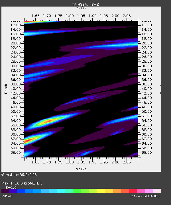
| Estimated Moho Depth: |
10.0 km |
| Estimated Crust Vp/Vs: |
1.60 |
| Assumed Crust Vp: |
6.552 km/s |
| Estimated Crust Vs: |
4.095 km/s |
| Estimated Crust Poisson's Ratio: |
0.18 |
|
| Radial Match: |
89.04125 % |
| Radial Bump: |
400 |
| Transverse Match: |
64.593575 % |
| Transverse Bump: |
400 |
| SOD ConfigId: |
410809 |
| Insert Time: |
2012-01-04 02:02:38.556 +0000 |
| GWidth: |
2.5 |
| Max Bumps: |
400 |
| Tol: |
0.001 |
|
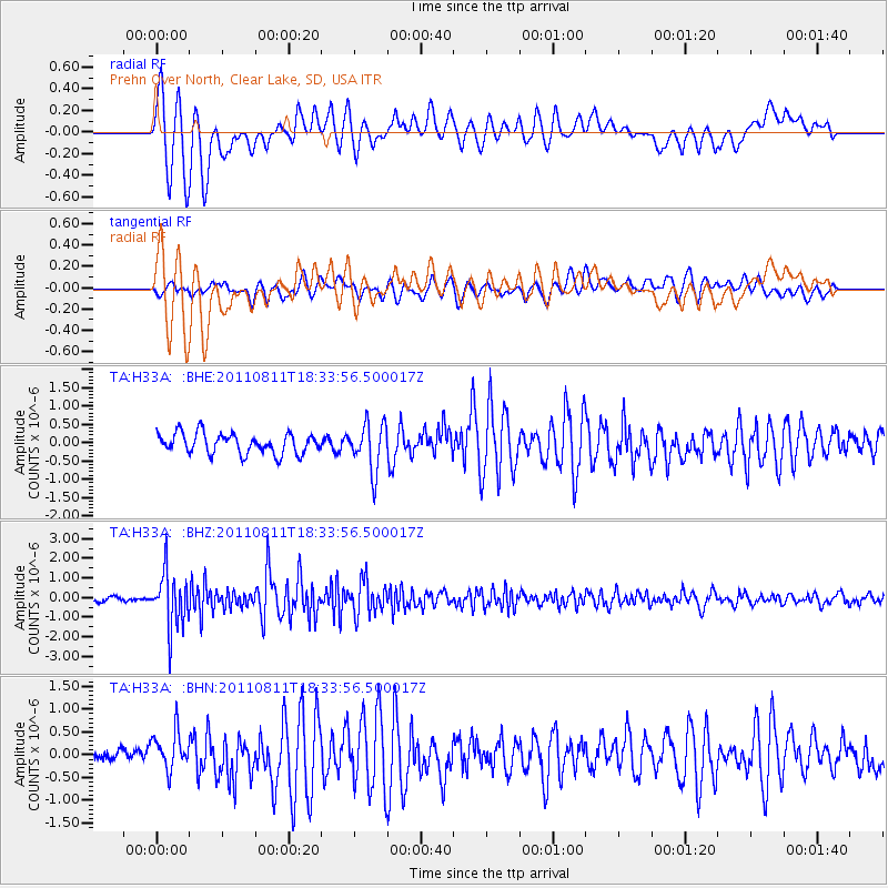
Signal To Noise
| Channel | StoN | STA | LTA |
| TA:H33A: :BHZ:20110811T18:33:56.500017Z | 14.524668 | 1.3936251E-6 | 9.594884E-8 |
| TA:H33A: :BHN:20110811T18:33:56.500017Z | 1.7247608 | 4.060886E-7 | 2.3544632E-7 |
| TA:H33A: :BHE:20110811T18:33:56.500017Z | 2.32477 | 6.414451E-7 | 2.7591767E-7 |
| Arrivals |
| Ps | 0.9 SECOND |
| PpPs | 3.9 SECOND |
| PsPs/PpSs | 4.8 SECOND |


