You are here: Home > Network List > TA - USArray Transportable Network (new EarthScope stations) Stations List
> Station G31A Conde, SD, USA > Earthquake Result Viewer
G31A Conde, SD, USA - Earthquake Result Viewer
| Earthquake location: |
Eastern Honshu, Japan |
| Earthquake latitude/longitude: |
37.0/140.9 |
| Earthquake time(UTC): |
2011/08/11 (223) 18:22:04 GMT |
| Earthquake Depth: |
44 km |
| Earthquake Magnitude: |
6.0 MB, 5.3 MS, 5.9 MW, 5.9 MW |
| Earthquake Catalog/Contributor: |
WHDF/NEIC |
|
| Network: |
TA USArray Transportable Network (new EarthScope stations) |
| Station: |
G31A Conde, SD, USA |
| Lat/Lon: |
45.23 N/98.21 W |
| Elevation: |
393 m |
|
| Distance: |
82.3 deg |
| Az: |
37.728 deg |
| Baz: |
316.141 deg |
| Ray Param: |
0.04690838 |
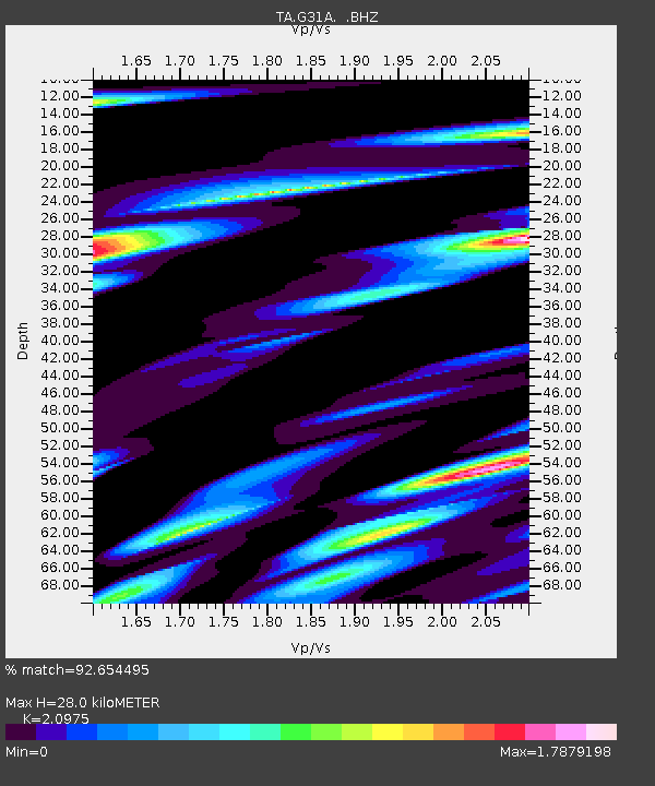
| Estimated Moho Depth: |
28.0 km |
| Estimated Crust Vp/Vs: |
2.10 |
| Assumed Crust Vp: |
6.53 km/s |
| Estimated Crust Vs: |
3.113 km/s |
| Estimated Crust Poisson's Ratio: |
0.35 |
|
| Radial Match: |
92.654495 % |
| Radial Bump: |
400 |
| Transverse Match: |
72.812256 % |
| Transverse Bump: |
400 |
| SOD ConfigId: |
410809 |
| Insert Time: |
2012-01-04 02:06:10.990 +0000 |
| GWidth: |
2.5 |
| Max Bumps: |
400 |
| Tol: |
0.001 |
|

Signal To Noise
| Channel | StoN | STA | LTA |
| TA:G31A: :BHZ:20110811T18:33:50.77498Z | 11.27303 | 1.4024636E-6 | 1.2440874E-7 |
| TA:G31A: :BHN:20110811T18:33:50.77498Z | 3.0377471 | 1.0289624E-6 | 3.387255E-7 |
| TA:G31A: :BHE:20110811T18:33:50.77498Z | 3.8854527 | 9.609911E-7 | 2.4733052E-7 |
| Arrivals |
| Ps | 4.8 SECOND |
| PpPs | 13 SECOND |
| PsPs/PpSs | 18 SECOND |


