You are here: Home > Network List > TA - USArray Transportable Network (new EarthScope stations) Stations List
> Station G33A Ortonville, MN, USA > Earthquake Result Viewer
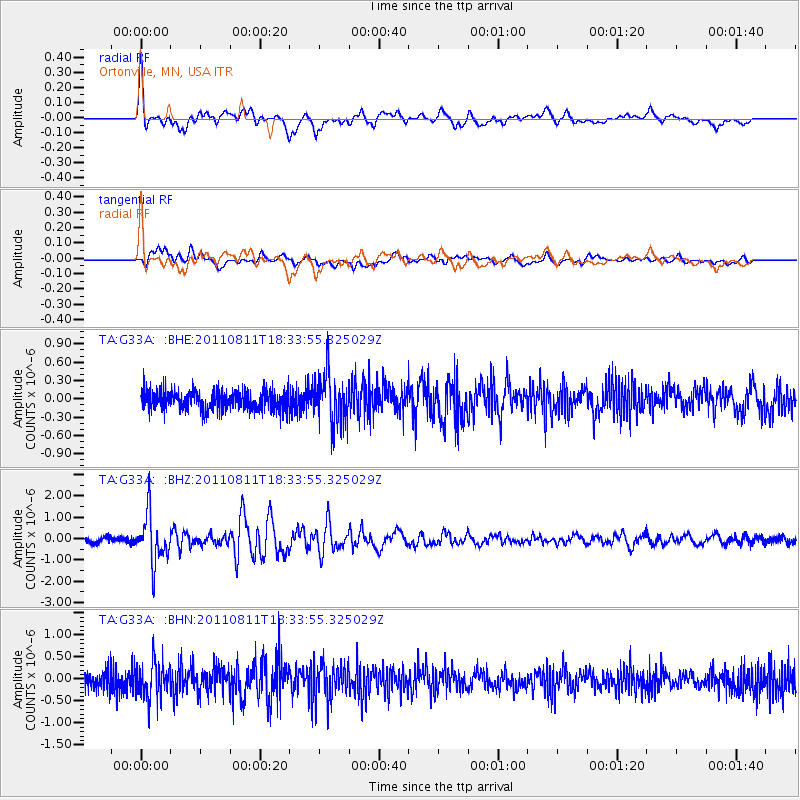
G33A Ortonville, MN, USA - Earthquake Result Viewer

| Earthquake location: |
Eastern Honshu, Japan |
| Earthquake latitude/longitude: |
37.0/140.9 |
| Earthquake time(UTC): |
2011/08/11 (223) 18:22:04 GMT |
| Earthquake Depth: |
44 km |
| Earthquake Magnitude: |
6.0 MB, 5.3 MS, 5.9 MW, 5.9 MW |
| Earthquake Catalog/Contributor: |
WHDF/NEIC |
|
| Network: |
TA USArray Transportable Network (new EarthScope stations) |
| Station: |
G33A Ortonville, MN, USA |
| Lat/Lon: |
45.19 N/96.44 W |
| Elevation: |
338 m |
|
| Distance: |
83.2 deg |
| Az: |
36.831 deg |
| Baz: |
317.28 deg |
| Ray Param: |
0.046296474 |
| Estimated Moho Depth: |
52.5 km |
| Estimated Crust Vp/Vs: |
1.60 |
| Assumed Crust Vp: |
6.552 km/s |
| Estimated Crust Vs: |
4.095 km/s |
| Estimated Crust Poisson's Ratio: |
0.18 |
|
| Radial Match: |
86.64241 % |
| Radial Bump: |
400 |
| Transverse Match: |
63.95646 % |
| Transverse Bump: |
400 |
| SOD ConfigId: |
410809 |
| Insert Time: |
2012-01-04 02:08:05.124 +0000 |
| GWidth: |
2.5 |
| Max Bumps: |
400 |
| Tol: |
0.001 |
|
Signal To Noise
| Channel | StoN | STA | LTA |
| TA:G33A: :BHZ:20110811T18:33:55.325029Z | 9.3540945 | 1.1164086E-6 | 1.1934972E-7 |
| TA:G33A: :BHN:20110811T18:33:55.325029Z | 2.1070166 | 4.0051341E-7 | 1.9008554E-7 |
| TA:G33A: :BHE:20110811T18:33:55.325029Z | 2.525774 | 3.9125916E-7 | 1.5490663E-7 |
| Arrivals |
| Ps | 5.0 SECOND |
| PpPs | 20 SECOND |
| PsPs/PpSs | 25 SECOND |


