You are here: Home > Network List > TA - USArray Transportable Network (new EarthScope stations) Stations List
> Station B33A Robert and Kassanda Mosher, Grygla, MN, USA > Earthquake Result Viewer
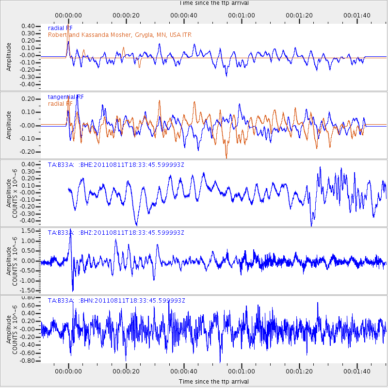
B33A Robert and Kassanda Mosher, Grygla, MN, USA - Earthquake Result Viewer
*The percent match for this event was below the threshold and hence no stack was calculated.
| Earthquake location: |
Eastern Honshu, Japan |
| Earthquake latitude/longitude: |
37.0/140.9 |
| Earthquake time(UTC): |
2011/08/11 (223) 18:22:04 GMT |
| Earthquake Depth: |
44 km |
| Earthquake Magnitude: |
6.0 MB, 5.3 MS, 5.9 MW, 5.9 MW |
| Earthquake Catalog/Contributor: |
WHDF/NEIC |
|
| Network: |
TA USArray Transportable Network (new EarthScope stations) |
| Station: |
B33A Robert and Kassanda Mosher, Grygla, MN, USA |
| Lat/Lon: |
48.27 N/95.59 W |
| Elevation: |
362 m |
|
| Distance: |
81.3 deg |
| Az: |
34.294 deg |
| Baz: |
317.555 deg |
| Ray Param: |
$rayparam |
*The percent match for this event was below the threshold and hence was not used in the summary stack. |
|
| Radial Match: |
63.01736 % |
| Radial Bump: |
400 |
| Transverse Match: |
55.945026 % |
| Transverse Bump: |
400 |
| SOD ConfigId: |
410809 |
| Insert Time: |
2012-01-04 02:09:00.783 +0000 |
| GWidth: |
2.5 |
| Max Bumps: |
400 |
| Tol: |
0.001 |
|
Signal To Noise
| Channel | StoN | STA | LTA |
| TA:B33A: :BHZ:20110811T18:33:45.599993Z | 5.1901608 | 6.175127E-7 | 1.1897756E-7 |
| TA:B33A: :BHN:20110811T18:33:45.599993Z | 1.9394128 | 2.419957E-7 | 1.2477783E-7 |
| TA:B33A: :BHE:20110811T18:33:45.599993Z | 0.7041087 | 9.828152E-8 | 1.3958287E-7 |
| Arrivals |
| Ps | |
| PpPs | |
| PsPs/PpSs | |


