You are here: Home > Network List > TA - USArray Transportable Network (new EarthScope stations) Stations List
> Station Y47A UCPARC, Winfield, AL, USA > Earthquake Result Viewer
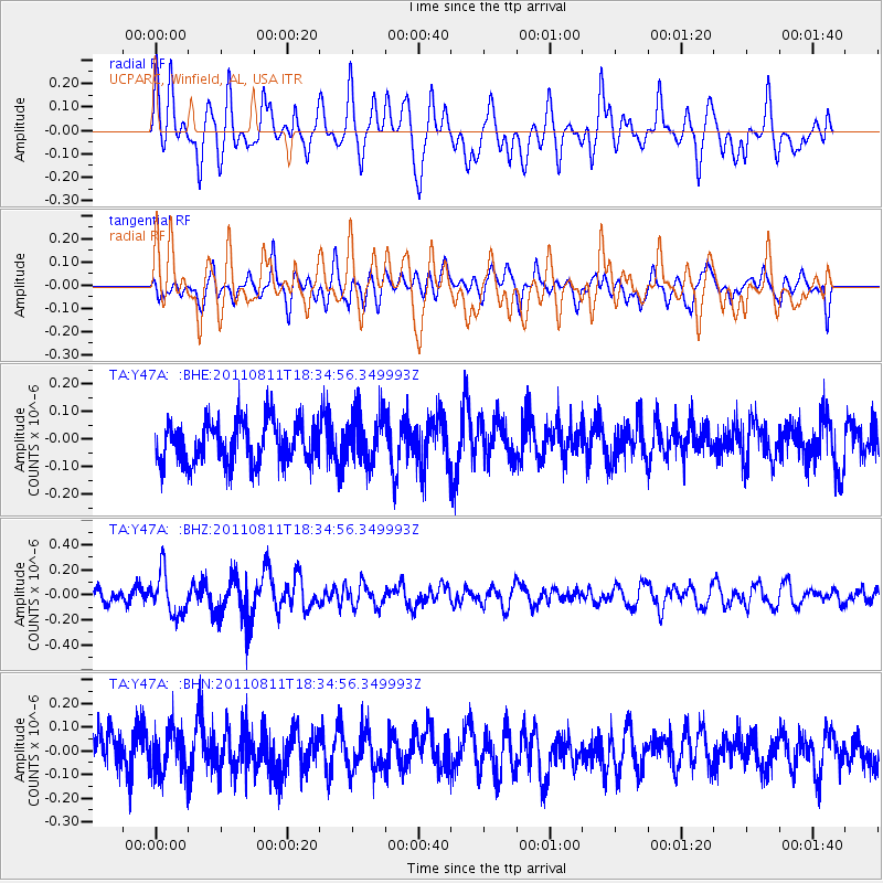
Y47A UCPARC, Winfield, AL, USA - Earthquake Result Viewer
*The percent match for this event was below the threshold and hence no stack was calculated.
| Earthquake location: |
Eastern Honshu, Japan |
| Earthquake latitude/longitude: |
37.0/140.9 |
| Earthquake time(UTC): |
2011/08/11 (223) 18:22:04 GMT |
| Earthquake Depth: |
44 km |
| Earthquake Magnitude: |
6.0 MB, 5.3 MS, 5.9 MW, 5.9 MW |
| Earthquake Catalog/Contributor: |
WHDF/NEIC |
|
| Network: |
TA USArray Transportable Network (new EarthScope stations) |
| Station: |
Y47A UCPARC, Winfield, AL, USA |
| Lat/Lon: |
33.90 N/87.85 W |
| Elevation: |
160 m |
|
| Distance: |
96.1 deg |
| Az: |
38.96 deg |
| Baz: |
322.773 deg |
| Ray Param: |
$rayparam |
*The percent match for this event was below the threshold and hence was not used in the summary stack. |
|
| Radial Match: |
45.42628 % |
| Radial Bump: |
400 |
| Transverse Match: |
56.68278 % |
| Transverse Bump: |
400 |
| SOD ConfigId: |
410809 |
| Insert Time: |
2012-01-04 02:14:50.337 +0000 |
| GWidth: |
2.5 |
| Max Bumps: |
400 |
| Tol: |
0.001 |
|
Signal To Noise
| Channel | StoN | STA | LTA |
| TA:Y47A: :BHZ:20110811T18:34:56.349993Z | 3.5714295 | 1.6670948E-7 | 4.6678643E-8 |
| TA:Y47A: :BHN:20110811T18:34:56.349993Z | 1.1364044 | 9.563024E-8 | 8.4151594E-8 |
| TA:Y47A: :BHE:20110811T18:34:56.349993Z | 1.1725901 | 8.735814E-8 | 7.450015E-8 |
| Arrivals |
| Ps | |
| PpPs | |
| PsPs/PpSs | |


