You are here: Home > Network List > TA - USArray Transportable Network (new EarthScope stations) Stations List
> Station U41A Viola, AR, USA > Earthquake Result Viewer
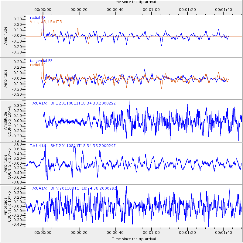
U41A Viola, AR, USA - Earthquake Result Viewer
*The percent match for this event was below the threshold and hence no stack was calculated.
| Earthquake location: |
Eastern Honshu, Japan |
| Earthquake latitude/longitude: |
37.0/140.9 |
| Earthquake time(UTC): |
2011/08/11 (223) 18:22:04 GMT |
| Earthquake Depth: |
44 km |
| Earthquake Magnitude: |
6.0 MB, 5.3 MS, 5.9 MW, 5.9 MW |
| Earthquake Catalog/Contributor: |
WHDF/NEIC |
|
| Network: |
TA USArray Transportable Network (new EarthScope stations) |
| Station: |
U41A Viola, AR, USA |
| Lat/Lon: |
36.34 N/91.92 W |
| Elevation: |
300 m |
|
| Distance: |
92.1 deg |
| Az: |
40.064 deg |
| Baz: |
320.362 deg |
| Ray Param: |
$rayparam |
*The percent match for this event was below the threshold and hence was not used in the summary stack. |
|
| Radial Match: |
63.199146 % |
| Radial Bump: |
400 |
| Transverse Match: |
69.459366 % |
| Transverse Bump: |
400 |
| SOD ConfigId: |
410809 |
| Insert Time: |
2012-01-04 02:18:57.903 +0000 |
| GWidth: |
2.5 |
| Max Bumps: |
400 |
| Tol: |
0.001 |
|
Signal To Noise
| Channel | StoN | STA | LTA |
| TA:U41A: :BHZ:20110811T18:34:38.200029Z | 5.150828 | 3.4067395E-7 | 6.613965E-8 |
| TA:U41A: :BHN:20110811T18:34:38.200029Z | 2.05209 | 1.5575041E-7 | 7.589843E-8 |
| TA:U41A: :BHE:20110811T18:34:38.200029Z | 2.0550468 | 1.10598414E-7 | 5.3817956E-8 |
| Arrivals |
| Ps | |
| PpPs | |
| PsPs/PpSs | |


