You are here: Home > Network List > G - GEOSCOPE Stations List
> Station DRV Dumont d'Urville, Terre Adelie (Antartica) > Earthquake Result Viewer
DRV Dumont d'Urville, Terre Adelie (Antartica) - Earthquake Result Viewer
| Earthquake location: |
Fiji Islands Region |
| Earthquake latitude/longitude: |
-17.8/-178.5 |
| Earthquake time(UTC): |
1994/03/09 (068) 23:28:07 GMT |
| Earthquake Depth: |
564 km |
| Earthquake Magnitude: |
6.6 MB, 7.6 UNKNOWN, 7.6 MW |
| Earthquake Catalog/Contributor: |
WHDF/NEIC |
|
| Network: |
G GEOSCOPE |
| Station: |
DRV Dumont d'Urville, Terre Adelie (Antartica) |
| Lat/Lon: |
66.67 S/140.01 E |
| Elevation: |
40 m |
|
| Distance: |
55.8 deg |
| Az: |
198.614 deg |
| Baz: |
49.775 deg |
| Ray Param: |
0.06220785 |
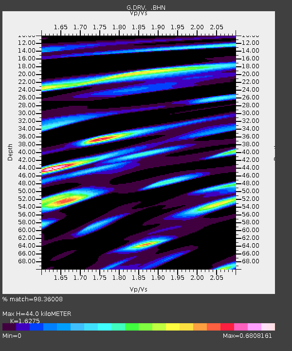
| Estimated Moho Depth: |
44.0 km |
| Estimated Crust Vp/Vs: |
1.63 |
| Assumed Crust Vp: |
6.39 km/s |
| Estimated Crust Vs: |
3.926 km/s |
| Estimated Crust Poisson's Ratio: |
0.20 |
|
| Radial Match: |
98.36008 % |
| Radial Bump: |
365 |
| Transverse Match: |
93.5522 % |
| Transverse Bump: |
400 |
| SOD ConfigId: |
16938 |
| Insert Time: |
2010-02-26 22:00:42.784 +0000 |
| GWidth: |
2.5 |
| Max Bumps: |
400 |
| Tol: |
0.001 |
|
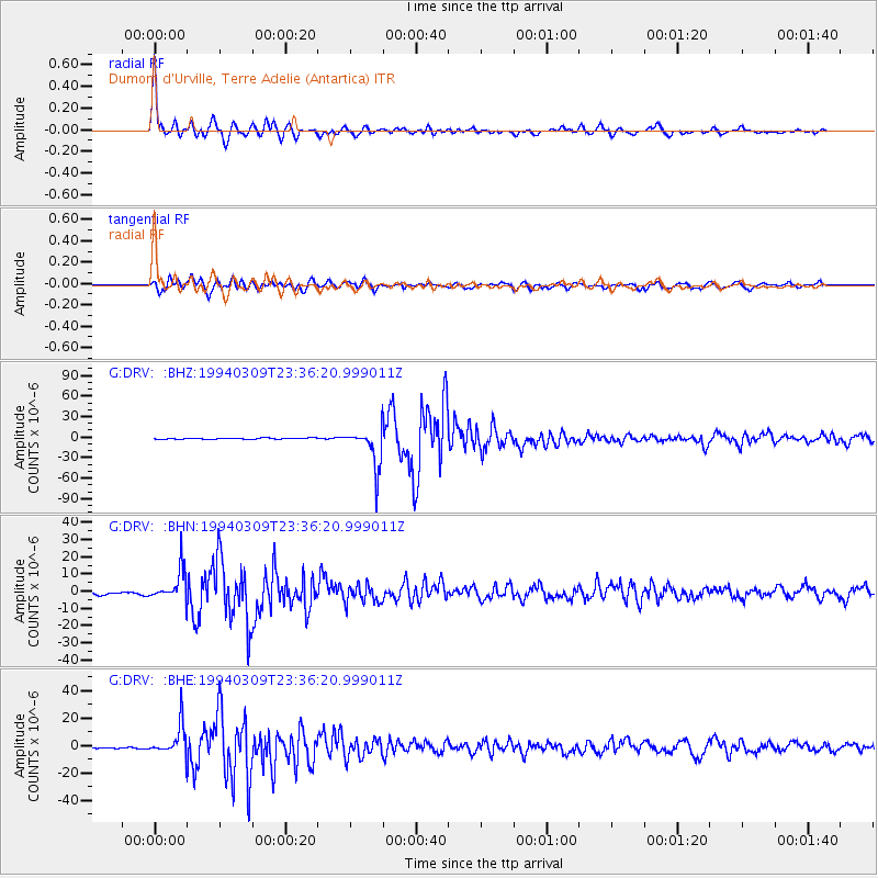
Signal To Noise
| Channel | StoN | STA | LTA |
| G:DRV: :BHN:19940309T23:36:20.999011Z | 9.099053 | 9.117557E-6 | 1.0020336E-6 |
| G:DRV: :BHE:19940309T23:36:20.999011Z | 15.057504 | 1.1144468E-5 | 7.401272E-7 |
| G:DRV: :BHZ:19940309T23:36:20.999011Z | 32.647423 | 2.8670644E-5 | 8.7819006E-7 |
| Arrivals |
| Ps | 4.5 SECOND |
| PpPs | 17 SECOND |
| PsPs/PpSs | 22 SECOND |


