You are here: Home > Network List > UW - Pacific Northwest Regional Seismic Network Stations List
> Station LEBA Lebam, WA, USA > Earthquake Result Viewer
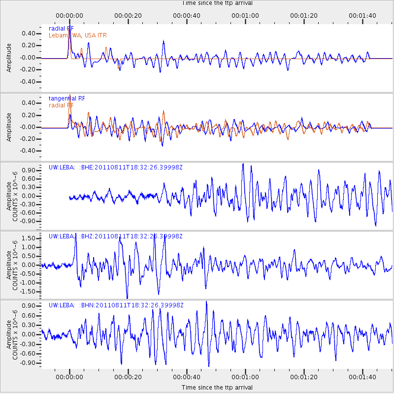
LEBA Lebam, WA, USA - Earthquake Result Viewer
*The percent match for this event was below the threshold and hence no stack was calculated.
| Earthquake location: |
Eastern Honshu, Japan |
| Earthquake latitude/longitude: |
37.0/140.9 |
| Earthquake time(UTC): |
2011/08/11 (223) 18:22:04 GMT |
| Earthquake Depth: |
44 km |
| Earthquake Magnitude: |
6.0 MB, 5.3 MS, 5.9 MW, 5.9 MW |
| Earthquake Catalog/Contributor: |
WHDF/NEIC |
|
| Network: |
UW Pacific Northwest Regional Seismic Network |
| Station: |
LEBA Lebam, WA, USA |
| Lat/Lon: |
46.55 N/123.56 W |
| Elevation: |
73 m |
|
| Distance: |
67.6 deg |
| Az: |
47.978 deg |
| Baz: |
300.538 deg |
| Ray Param: |
$rayparam |
*The percent match for this event was below the threshold and hence was not used in the summary stack. |
|
| Radial Match: |
79.61681 % |
| Radial Bump: |
400 |
| Transverse Match: |
82.19548 % |
| Transverse Bump: |
400 |
| SOD ConfigId: |
410809 |
| Insert Time: |
2012-01-04 02:22:23.523 +0000 |
| GWidth: |
2.5 |
| Max Bumps: |
400 |
| Tol: |
0.001 |
|
Signal To Noise
| Channel | StoN | STA | LTA |
| UW:LEBA: :BHZ:20110811T18:32:26.39998Z | 8.961429 | 6.9117283E-7 | 7.7127524E-8 |
| UW:LEBA: :BHN:20110811T18:32:26.39998Z | 2.121521 | 1.8401894E-7 | 8.6739156E-8 |
| UW:LEBA: :BHE:20110811T18:32:26.39998Z | 2.074576 | 2.0075862E-7 | 9.677091E-8 |
| Arrivals |
| Ps | |
| PpPs | |
| PsPs/PpSs | |


