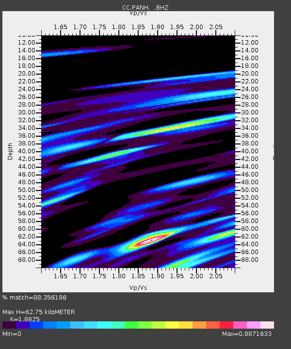
PANH Panhandle Gap, Mt. Rainier, WA - Earthquake Result Viewer

Earthquake location: Off Coast Of Chiapas, Mexico
Earthquake latitude/longitude: 14.4/-94.7
Earthquake time(UTC): 2011/08/13 (225) 07:33:06 GMT
Earthquake Depth: 6.0 km
Earthquake Magnitude: 5.7 MB, 5.2 MS, 5.8 MW, 5.6 MW
Earthquake Catalog/Contributor: WHDF/NEIC
Network: CC Cascade Chain Volcano Monitoring
Station: PANH Panhandle Gap, Mt. Rainier, WA
Lat/Lon: 46.86 N/121.64 W
Elevation: 2109 m
Distance: 39.4 deg
Az: 330.664 deg
Baz: 136.226 deg
Ray Param: 0.07499575
Estimated Moho Depth: 62.75 km
Estimated Crust Vp/Vs: 1.88
Assumed Crust Vp: 6.597 km/s
Estimated Crust Vs: 3.505 km/s
Estimated Crust Poisson's Ratio: 0.30
Radial Match: 88.356186 %
Radial Bump: 400
Transverse Match: 70.94677 %
Transverse Bump: 400
SOD ConfigId: 410809
Insert Time: 2012-01-06 04:40:22.982 +0000
GWidth: 2.5
Max Bumps: 400
Tol: 0.001

Signal To Noise

ChannelStoNSTALTA
CC:PANH: :BHZ:20110813T07:40:06.019994Z5.80047131.2084536E-62.0833714E-7
CC:PANH: :BHN:20110813T07:40:06.019994Z6.03471856.5555895E-71.0863125E-7
CC:PANH: :BHE:20110813T07:40:06.019994Z3.4621327.473303E-72.158584E-7
Arrivals
Ps9.0 SECOND
PpPs26 SECOND
PsPs/PpSs35 SECOND