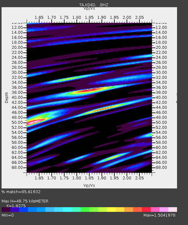
K04D Chiloquin, OR, USA - Earthquake Result Viewer
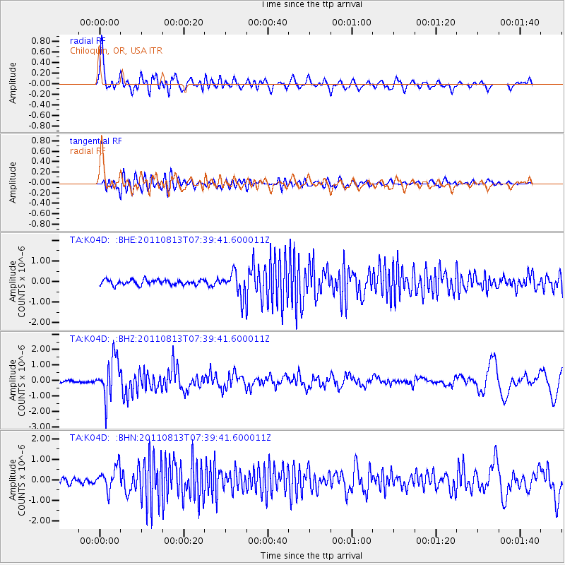
Earthquake location: Off Coast Of Chiapas, Mexico
Earthquake latitude/longitude: 14.4/-94.7
Earthquake time(UTC): 2011/08/13 (225) 07:33:06 GMT
Earthquake Depth: 6.0 km
Earthquake Magnitude: 5.7 MB, 5.2 MS, 5.8 MW, 5.6 MW
Earthquake Catalog/Contributor: WHDF/NEIC
Network: TA USArray Transportable Network (new EarthScope stations)
Station: K04D Chiloquin, OR, USA
Lat/Lon: 42.62 N/121.75 W
Elevation: 1315 m
Distance: 36.5 deg
Az: 325.643 deg
Baz: 132.188 deg
Ray Param: 0.07663616
Estimated Moho Depth: 49.75 km
Estimated Crust Vp/Vs: 1.63
Assumed Crust Vp: 6.597 km/s
Estimated Crust Vs: 4.054 km/s
Estimated Crust Poisson's Ratio: 0.20
Radial Match: 85.61932 %
Radial Bump: 400
Transverse Match: 53.6403 %
Transverse Bump: 400
SOD ConfigId: 410809
Insert Time: 2012-01-06 04:51:08.958 +0000
GWidth: 2.5
Max Bumps: 400
Tol: 0.001

Signal To Noise

ChannelStoNSTALTA
TA:K04D: :BHZ:20110813T07:39:41.600011Z14.7652711.2890521E-68.730298E-8
TA:K04D: :BHN:20110813T07:39:41.600011Z3.9028075.727155E-71.4674451E-7
TA:K04D: :BHE:20110813T07:39:41.600011Z4.8954026.041931E-71.2342052E-7
Arrivals
Ps5.2 SECOND
PpPs18 SECOND
PsPs/PpSs23 SECOND