DRV Dumont d'Urville, Terre Adelie (Antartica) - Earthquake Result Viewer
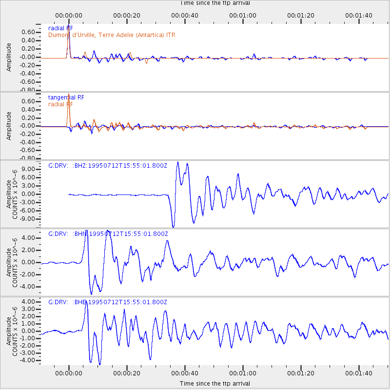
Earthquake location: Southeast Of Loyalty Islands
Earthquake latitude/longitude: -23.2/170.8
Earthquake time(UTC): 1995/07/12 (193) 15:46:59 GMT
Earthquake Depth: 33 km
Earthquake Magnitude: 5.9 MB, 6.4 MS, 6.5 UNKNOWN, 6.4 MW
Earthquake Catalog/Contributor: WHDF/NEIC
Network: G GEOSCOPE
Station: DRV Dumont d'Urville, Terre Adelie (Antartica)
Lat/Lon: 66.67 S/140.01 E
Elevation: 40 m
Distance: 47.6 deg
Az: 196.046 deg
Baz: 39.661 deg
Ray Param: 0.069833435
Estimated Moho Depth: 23.25 km
Estimated Crust Vp/Vs: 1.60
Assumed Crust Vp: 6.39 km/s
Estimated Crust Vs: 3.994 km/s
Estimated Crust Poisson's Ratio: 0.18
Radial Match: 97.41658 %
Radial Bump: 253
Transverse Match: 92.12553 %
Transverse Bump: 400
SOD ConfigId: 6273
Insert Time: 2010-02-26 22:01:28.183 +0000
GWidth: 2.5
Max Bumps: 400
Tol: 0.001

Signal To Noise

ChannelStoNSTALTA
G:DRV: :BHN:19950712T15:55:01.800Z2.6221563.308727E-71.2618345E-7
G:DRV: :BHE:19950712T15:55:01.800Z0.80442262.0139186E-72.5035578E-7
G:DRV: :BHZ:19950712T15:55:01.800Z5.01644375.3437907E-71.0652548E-7
Arrivals
Ps2.3 SECOND
PpPs8.8 SECOND
PsPs/PpSs11 SECOND