You are here: Home > Network List > TA - USArray Transportable Network (new EarthScope stations) Stations List
> Station H34A Spellman Lake, Hanley Falls, MN, USA > Earthquake Result Viewer
H34A Spellman Lake, Hanley Falls, MN, USA - Earthquake Result Viewer
| Earthquake location: |
Off Coast Of Chiapas, Mexico |
| Earthquake latitude/longitude: |
14.4/-94.7 |
| Earthquake time(UTC): |
2011/08/13 (225) 07:33:06 GMT |
| Earthquake Depth: |
6.0 km |
| Earthquake Magnitude: |
5.7 MB, 5.2 MS, 5.8 MW, 5.6 MW |
| Earthquake Catalog/Contributor: |
WHDF/NEIC |
|
| Network: |
TA USArray Transportable Network (new EarthScope stations) |
| Station: |
H34A Spellman Lake, Hanley Falls, MN, USA |
| Lat/Lon: |
44.67 N/95.78 W |
| Elevation: |
329 m |
|
| Distance: |
30.2 deg |
| Az: |
358.435 deg |
| Baz: |
177.874 deg |
| Ray Param: |
0.07940269 |
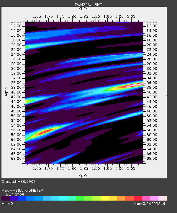
| Estimated Moho Depth: |
36.5 km |
| Estimated Crust Vp/Vs: |
2.07 |
| Assumed Crust Vp: |
6.571 km/s |
| Estimated Crust Vs: |
3.17 km/s |
| Estimated Crust Poisson's Ratio: |
0.35 |
|
| Radial Match: |
88.1907 % |
| Radial Bump: |
356 |
| Transverse Match: |
70.56297 % |
| Transverse Bump: |
400 |
| SOD ConfigId: |
410809 |
| Insert Time: |
2012-01-06 04:52:39.966 +0000 |
| GWidth: |
2.5 |
| Max Bumps: |
400 |
| Tol: |
0.001 |
|
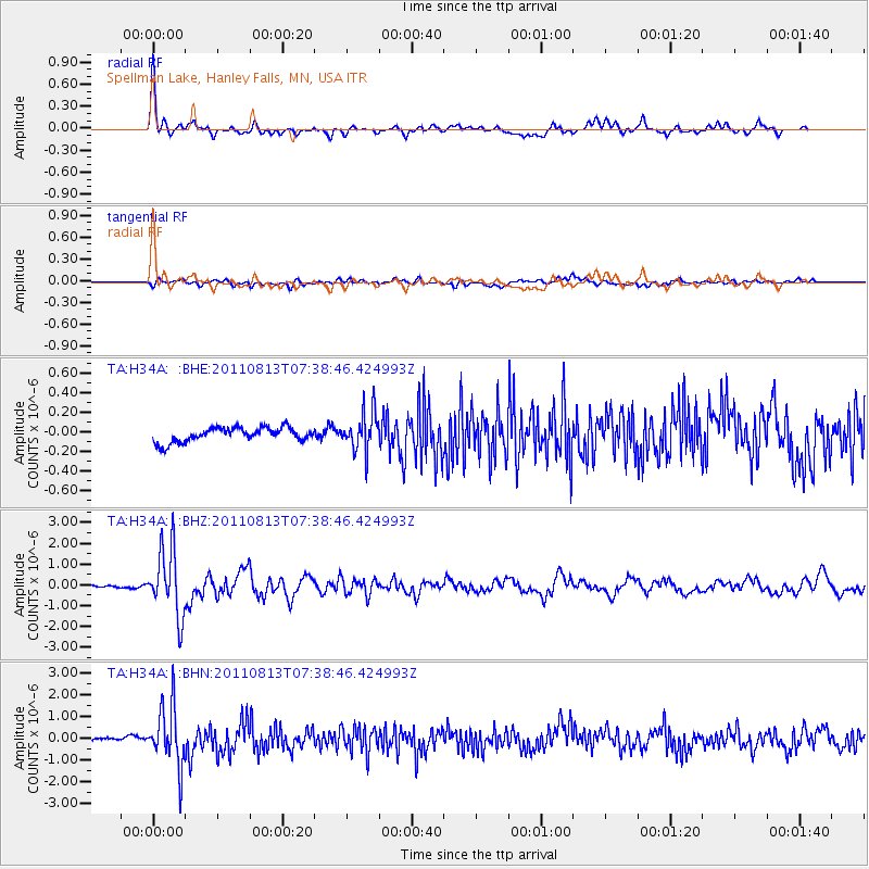
Signal To Noise
| Channel | StoN | STA | LTA |
| TA:H34A: :BHZ:20110813T07:38:46.424993Z | 21.970213 | 1.6005529E-6 | 7.285104E-8 |
| TA:H34A: :BHN:20110813T07:38:46.424993Z | 18.374483 | 1.3601497E-6 | 7.402384E-8 |
| TA:H34A: :BHE:20110813T07:38:46.424993Z | 2.7025967 | 1.9871818E-7 | 7.352861E-8 |
| Arrivals |
| Ps | 6.4 SECOND |
| PpPs | 16 SECOND |
| PsPs/PpSs | 22 SECOND |


