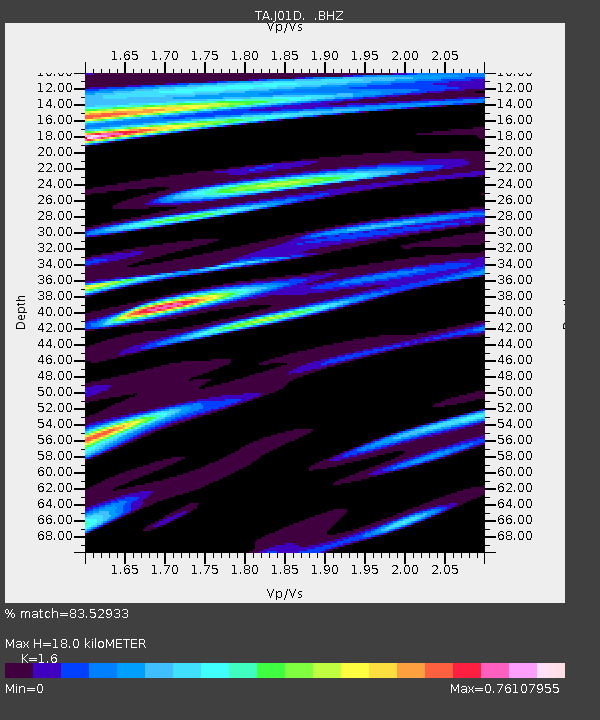
J01D Myrtle Point, OR, USA - Earthquake Result Viewer
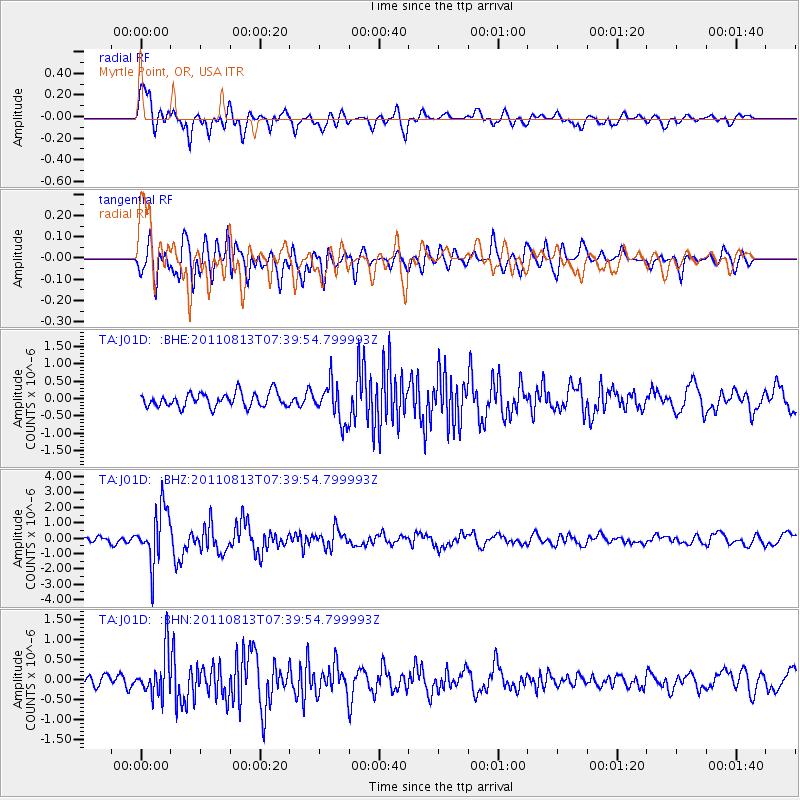
Earthquake location: Off Coast Of Chiapas, Mexico
Earthquake latitude/longitude: 14.4/-94.7
Earthquake time(UTC): 2011/08/13 (225) 07:33:06 GMT
Earthquake Depth: 6.0 km
Earthquake Magnitude: 5.7 MB, 5.2 MS, 5.8 MW, 5.6 MW
Earthquake Catalog/Contributor: WHDF/NEIC
Network: TA USArray Transportable Network (new EarthScope stations)
Station: J01D Myrtle Point, OR, USA
Lat/Lon: 43.16 N/123.93 W
Elevation: 131 m
Distance: 38.1 deg
Az: 324.577 deg
Baz: 129.864 deg
Ray Param: 0.07576894
Estimated Moho Depth: 18.0 km
Estimated Crust Vp/Vs: 1.60
Assumed Crust Vp: 6.522 km/s
Estimated Crust Vs: 4.076 km/s
Estimated Crust Poisson's Ratio: 0.18
Radial Match: 83.52933 %
Radial Bump: 400
Transverse Match: 80.63082 %
Transverse Bump: 400
SOD ConfigId: 410809
Insert Time: 2012-01-06 04:53:24.068 +0000
GWidth: 2.5
Max Bumps: 400
Tol: 0.001

Signal To Noise

ChannelStoNSTALTA
TA:J01D: :BHZ:20110813T07:39:54.799993Z10.2895371.7788371E-61.7287825E-7
TA:J01D: :BHN:20110813T07:39:54.799993Z3.90235455.4910174E-71.4071036E-7
TA:J01D: :BHE:20110813T07:39:54.799993Z2.7049545.540245E-72.0481846E-7
Arrivals
Ps1.8 SECOND
PpPs6.6 SECOND
PsPs/PpSs8.4 SECOND