You are here: Home > Network List > TA - USArray Transportable Network (new EarthScope stations) Stations List
> Station D31A Mcclaflin, Tower City, ND, USA > Earthquake Result Viewer
D31A Mcclaflin, Tower City, ND, USA - Earthquake Result Viewer
| Earthquake location: |
Off Coast Of Chiapas, Mexico |
| Earthquake latitude/longitude: |
14.4/-94.7 |
| Earthquake time(UTC): |
2011/08/13 (225) 07:33:06 GMT |
| Earthquake Depth: |
6.0 km |
| Earthquake Magnitude: |
5.7 MB, 5.2 MS, 5.8 MW, 5.6 MW |
| Earthquake Catalog/Contributor: |
WHDF/NEIC |
|
| Network: |
TA USArray Transportable Network (new EarthScope stations) |
| Station: |
D31A Mcclaflin, Tower City, ND, USA |
| Lat/Lon: |
47.05 N/97.72 W |
| Elevation: |
359 m |
|
| Distance: |
32.7 deg |
| Az: |
356.135 deg |
| Baz: |
174.519 deg |
| Ray Param: |
0.07856763 |
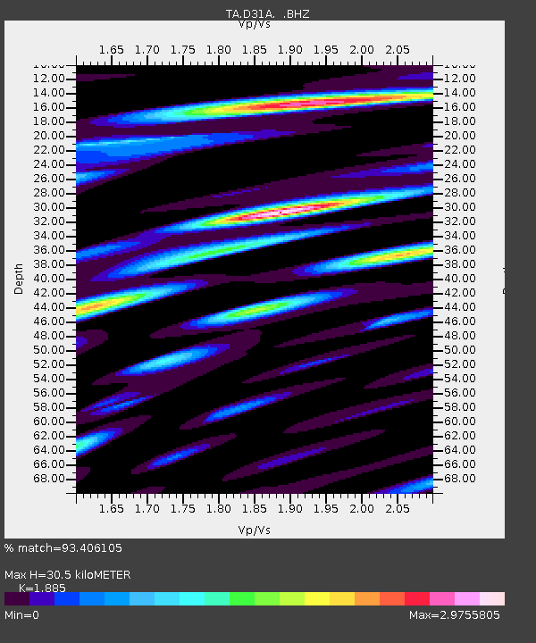
| Estimated Moho Depth: |
30.5 km |
| Estimated Crust Vp/Vs: |
1.88 |
| Assumed Crust Vp: |
6.498 km/s |
| Estimated Crust Vs: |
3.447 km/s |
| Estimated Crust Poisson's Ratio: |
0.30 |
|
| Radial Match: |
93.406105 % |
| Radial Bump: |
399 |
| Transverse Match: |
79.11071 % |
| Transverse Bump: |
400 |
| SOD ConfigId: |
410809 |
| Insert Time: |
2012-01-06 04:53:39.567 +0000 |
| GWidth: |
2.5 |
| Max Bumps: |
400 |
| Tol: |
0.001 |
|

Signal To Noise
| Channel | StoN | STA | LTA |
| TA:D31A: :BHZ:20110813T07:39:08.100011Z | 22.582708 | 1.4604144E-6 | 6.466959E-8 |
| TA:D31A: :BHN:20110813T07:39:08.100011Z | 21.711012 | 2.2510164E-6 | 1.0368086E-7 |
| TA:D31A: :BHE:20110813T07:39:08.100011Z | 8.938147 | 7.012428E-7 | 7.845506E-8 |
| Arrivals |
| Ps | 4.5 SECOND |
| PpPs | 13 SECOND |
| PsPs/PpSs | 17 SECOND |


