You are here: Home > Network List > TA - USArray Transportable Network (new EarthScope stations) Stations List
> Station B31A Greenbush Farm, Park River, ND, USA > Earthquake Result Viewer
B31A Greenbush Farm, Park River, ND, USA - Earthquake Result Viewer

| Earthquake location: |
Off Coast Of Chiapas, Mexico |
| Earthquake latitude/longitude: |
14.4/-94.7 |
| Earthquake time(UTC): |
2011/08/13 (225) 07:33:06 GMT |
| Earthquake Depth: |
6.0 km |
| Earthquake Magnitude: |
5.7 MB, 5.2 MS, 5.8 MW, 5.6 MW |
| Earthquake Catalog/Contributor: |
WHDF/NEIC |
|
| Network: |
TA USArray Transportable Network (new EarthScope stations) |
| Station: |
B31A Greenbush Farm, Park River, ND, USA |
| Lat/Lon: |
48.42 N/97.65 W |
| Elevation: |
279 m |
|
| Distance: |
34.0 deg |
| Az: |
356.457 deg |
| Baz: |
174.842 deg |
| Ray Param: |
0.077947944 |
| Estimated Moho Depth: |
12.5 km |
| Estimated Crust Vp/Vs: |
1.77 |
| Assumed Crust Vp: |
6.498 km/s |
| Estimated Crust Vs: |
3.671 km/s |
| Estimated Crust Poisson's Ratio: |
0.27 |
|
| Radial Match: |
93.83799 % |
| Radial Bump: |
400 |
| Transverse Match: |
82.153 % |
| Transverse Bump: |
400 |
| SOD ConfigId: |
410809 |
| Insert Time: |
2012-01-06 04:53:52.587 +0000 |
| GWidth: |
2.5 |
| Max Bumps: |
400 |
| Tol: |
0.001 |
|
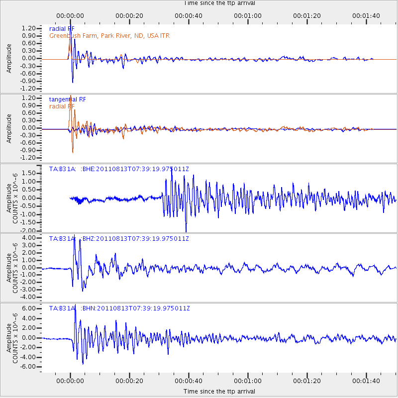
Signal To Noise
| Channel | StoN | STA | LTA |
| TA:B31A: :BHZ:20110813T07:39:19.975011Z | 36.398937 | 1.9645702E-6 | 5.397328E-8 |
| TA:B31A: :BHN:20110813T07:39:19.975011Z | 17.135883 | 2.7018293E-6 | 1.5767085E-7 |
| TA:B31A: :BHE:20110813T07:39:19.975011Z | 7.6965566 | 6.868812E-7 | 8.924526E-8 |
| Arrivals |
| Ps | 1.6 SECOND |
| PpPs | 4.9 SECOND |
| PsPs/PpSs | 6.5 SECOND |


