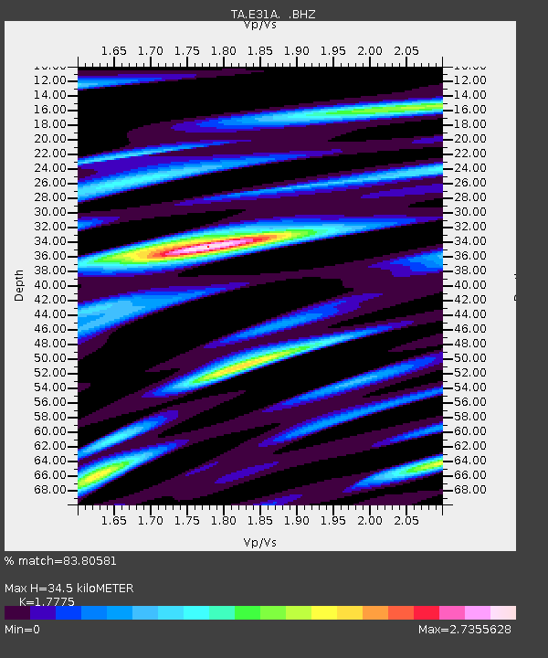
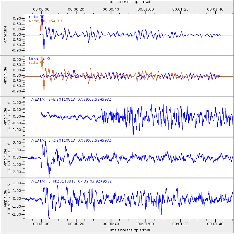
E31A Nome, ND, USA - Earthquake Result Viewer

Earthquake location: Off Coast Of Chiapas, Mexico
Earthquake latitude/longitude: 14.4/-94.7
Earthquake time(UTC): 2011/08/13 (225) 07:33:06 GMT
Earthquake Depth: 6.0 km
Earthquake Magnitude: 5.7 MB, 5.2 MS, 5.8 MW, 5.6 MW
Earthquake Catalog/Contributor: WHDF/NEIC
Network: TA USArray Transportable Network (new EarthScope stations)
Station: E31A Nome, ND, USA
Lat/Lon: 46.56 N/97.89 W
Elevation: 427 m
Distance: 32.2 deg
Az: 355.834 deg
Baz: 174.145 deg
Ray Param: 0.07877025
Estimated Moho Depth: 34.5 km
Estimated Crust Vp/Vs: 1.78
Assumed Crust Vp: 6.498 km/s
Estimated Crust Vs: 3.655 km/s
Estimated Crust Poisson's Ratio: 0.27
Radial Match: 83.80581 %
Radial Bump: 400
Transverse Match: 64.999535 %
Transverse Bump: 400
SOD ConfigId: 410809
Insert Time: 2012-01-06 04:54:18.404 +0000
GWidth: 2.5
Max Bumps: 400
Tol: 0.001

Signal To Noise

ChannelStoNSTALTA
TA:E31A: :BHZ:20110813T07:39:03.924993Z18.8776171.1985195E-66.348892E-8
TA:E31A: :BHN:20110813T07:39:03.924993Z9.197711.1906808E-61.2945405E-7
TA:E31A: :BHE:20110813T07:39:03.924993Z1.91264252.1416439E-71.11973044E-7
Arrivals
Ps4.5 SECOND
PpPs14 SECOND
PsPs/PpSs18 SECOND