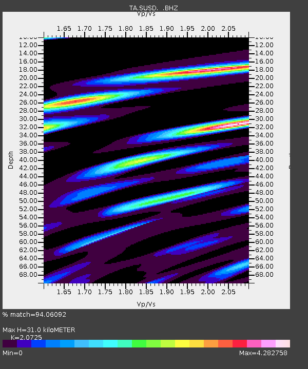
SUSD Miller, SD, USA - Earthquake Result Viewer

Earthquake location: Off Coast Of Chiapas, Mexico
Earthquake latitude/longitude: 14.4/-94.7
Earthquake time(UTC): 2011/08/13 (225) 07:33:06 GMT
Earthquake Depth: 6.0 km
Earthquake Magnitude: 5.7 MB, 5.2 MS, 5.8 MW, 5.6 MW
Earthquake Catalog/Contributor: WHDF/NEIC
Network: TA USArray Transportable Network (new EarthScope stations)
Station: SUSD Miller, SD, USA
Lat/Lon: 44.44 N/98.96 W
Elevation: 520 m
Distance: 30.2 deg
Az: 353.892 deg
Baz: 171.724 deg
Ray Param: 0.07940726
Estimated Moho Depth: 31.0 km
Estimated Crust Vp/Vs: 2.07
Assumed Crust Vp: 6.53 km/s
Estimated Crust Vs: 3.151 km/s
Estimated Crust Poisson's Ratio: 0.35
Radial Match: 94.06092 %
Radial Bump: 387
Transverse Match: 89.574394 %
Transverse Bump: 400
SOD ConfigId: 410809
Insert Time: 2012-01-06 04:54:56.159 +0000
GWidth: 2.5
Max Bumps: 400
Tol: 0.001

Signal To Noise

ChannelStoNSTALTA
TA:SUSD: :BHZ:20110813T07:38:46.274999Z19.6518341.4400491E-67.3278095E-8
TA:SUSD: :BHN:20110813T07:38:46.274999Z16.2809851.4910538E-69.158253E-8
TA:SUSD: :BHE:20110813T07:38:46.274999Z4.0191223.3628908E-78.367227E-8
Arrivals
Ps5.5 SECOND
PpPs14 SECOND
PsPs/PpSs19 SECOND