You are here: Home > Network List > TA - USArray Transportable Network (new EarthScope stations) Stations List
> Station A31A Linda, St. Vincent, MN, USA > Earthquake Result Viewer
A31A Linda, St. Vincent, MN, USA - Earthquake Result Viewer

| Earthquake location: |
Off Coast Of Chiapas, Mexico |
| Earthquake latitude/longitude: |
14.4/-94.7 |
| Earthquake time(UTC): |
2011/08/13 (225) 07:33:06 GMT |
| Earthquake Depth: |
6.0 km |
| Earthquake Magnitude: |
5.7 MB, 5.2 MS, 5.8 MW, 5.6 MW |
| Earthquake Catalog/Contributor: |
WHDF/NEIC |
|
| Network: |
TA USArray Transportable Network (new EarthScope stations) |
| Station: |
A31A Linda, St. Vincent, MN, USA |
| Lat/Lon: |
48.93 N/97.19 W |
| Elevation: |
244 m |
|
| Distance: |
34.5 deg |
| Az: |
357.072 deg |
| Baz: |
175.695 deg |
| Ray Param: |
0.07771801 |
| Estimated Moho Depth: |
17.75 km |
| Estimated Crust Vp/Vs: |
2.01 |
| Assumed Crust Vp: |
6.498 km/s |
| Estimated Crust Vs: |
3.229 km/s |
| Estimated Crust Poisson's Ratio: |
0.34 |
|
| Radial Match: |
83.60613 % |
| Radial Bump: |
400 |
| Transverse Match: |
65.529816 % |
| Transverse Bump: |
400 |
| SOD ConfigId: |
410809 |
| Insert Time: |
2012-01-06 04:55:09.996 +0000 |
| GWidth: |
2.5 |
| Max Bumps: |
400 |
| Tol: |
0.001 |
|
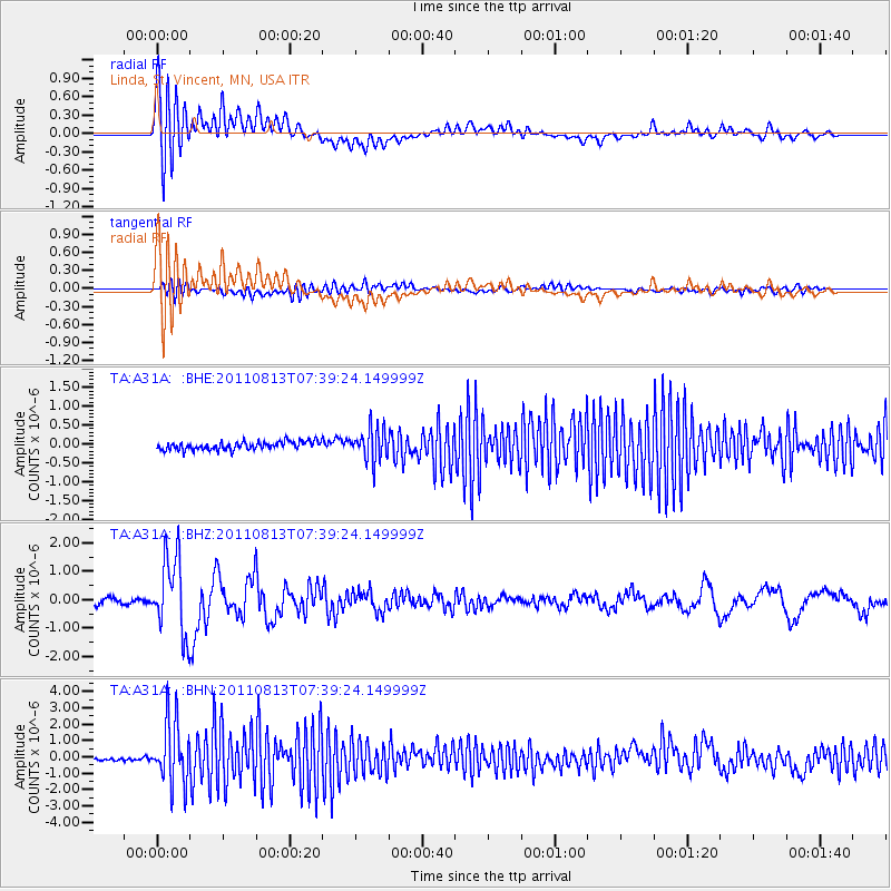
Signal To Noise
| Channel | StoN | STA | LTA |
| TA:A31A: :BHZ:20110813T07:39:24.149999Z | 14.489745 | 1.352367E-6 | 9.33327E-8 |
| TA:A31A: :BHN:20110813T07:39:24.149999Z | 19.181759 | 1.9494032E-6 | 1.01627975E-7 |
| TA:A31A: :BHE:20110813T07:39:24.149999Z | 3.9449267 | 4.2516834E-7 | 1.0777598E-7 |
| Arrivals |
| Ps | 3.0 SECOND |
| PpPs | 7.7 SECOND |
| PsPs/PpSs | 11 SECOND |


