D37A Cotton, MN, USA - Earthquake Result Viewer
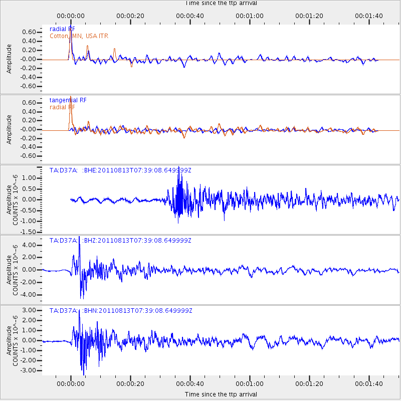
Earthquake location: Off Coast Of Chiapas, Mexico
Earthquake latitude/longitude: 14.4/-94.7
Earthquake time(UTC): 2011/08/13 (225) 07:33:06 GMT
Earthquake Depth: 6.0 km
Earthquake Magnitude: 5.7 MB, 5.2 MS, 5.8 MW, 5.6 MW
Earthquake Catalog/Contributor: WHDF/NEIC
Network: TA USArray Transportable Network (new EarthScope stations)
Station: D37A Cotton, MN, USA
Lat/Lon: 47.16 N/92.43 W
Elevation: 413 m
Distance: 32.7 deg
Az: 2.838 deg
Baz: 184.032 deg
Ray Param: 0.07854028
Estimated Moho Depth: 41.0 km
Estimated Crust Vp/Vs: 1.88
Assumed Crust Vp: 6.571 km/s
Estimated Crust Vs: 3.49 km/s
Estimated Crust Poisson's Ratio: 0.30
Radial Match: 93.4425 %
Radial Bump: 381
Transverse Match: 77.17286 %
Transverse Bump: 400
SOD ConfigId: 410809
Insert Time: 2012-01-06 04:55:50.322 +0000
GWidth: 2.5
Max Bumps: 400
Tol: 0.001

Signal To Noise

ChannelStoNSTALTA
TA:D37A: :BHZ:20110813T07:39:08.649999Z22.6247391.9336408E-68.546577E-8
TA:D37A: :BHN:20110813T07:39:08.649999Z30.6842731.2274172E-64.0001506E-8
TA:D37A: :BHE:20110813T07:39:08.649999Z3.21572762.0754386E-76.4540245E-8
Arrivals
Ps6.0 SECOND
PpPs17 SECOND
PsPs/PpSs23 SECOND