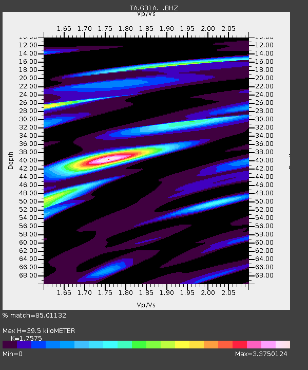
G31A Conde, SD, USA - Earthquake Result Viewer

Earthquake location: Off Coast Of Chiapas, Mexico
Earthquake latitude/longitude: 14.4/-94.7
Earthquake time(UTC): 2011/08/13 (225) 07:33:06 GMT
Earthquake Depth: 6.0 km
Earthquake Magnitude: 5.7 MB, 5.2 MS, 5.8 MW, 5.6 MW
Earthquake Catalog/Contributor: WHDF/NEIC
Network: TA USArray Transportable Network (new EarthScope stations)
Station: G31A Conde, SD, USA
Lat/Lon: 45.23 N/98.21 W
Elevation: 393 m
Distance: 30.9 deg
Az: 355.13 deg
Baz: 173.316 deg
Ray Param: 0.07922161
Estimated Moho Depth: 39.5 km
Estimated Crust Vp/Vs: 1.76
Assumed Crust Vp: 6.53 km/s
Estimated Crust Vs: 3.716 km/s
Estimated Crust Poisson's Ratio: 0.26
Radial Match: 85.01132 %
Radial Bump: 400
Transverse Match: 70.96796 %
Transverse Bump: 400
SOD ConfigId: 410809
Insert Time: 2012-01-06 04:56:04.268 +0000
GWidth: 2.5
Max Bumps: 400
Tol: 0.001

Signal To Noise

ChannelStoNSTALTA
TA:G31A: :BHZ:20110813T07:38:52.500005Z12.7431641.2936204E-61.0151485E-7
TA:G31A: :BHN:20110813T07:38:52.500005Z10.141291.4986039E-61.4777251E-7
TA:G31A: :BHE:20110813T07:38:52.500005Z2.31964182.8736622E-71.2388386E-7
Arrivals
Ps5.0 SECOND
PpPs15 SECOND
PsPs/PpSs20 SECOND