You are here: Home > Network List > G - GEOSCOPE Stations List
> Station DRV Dumont d'Urville, Terre Adelie (Antartica) > Earthquake Result Viewer
DRV Dumont d'Urville, Terre Adelie (Antartica) - Earthquake Result Viewer

| Earthquake location: |
Samar, Philippines |
| Earthquake latitude/longitude: |
12.1/125.9 |
| Earthquake time(UTC): |
1995/04/21 (111) 05:17:00 GMT |
| Earthquake Depth: |
23 km |
| Earthquake Magnitude: |
5.6 MB, 6.9 MS, 6.7 UNKNOWN, 6.7 MW |
| Earthquake Catalog/Contributor: |
WHDF/NEIC |
|
| Network: |
G GEOSCOPE |
| Station: |
DRV Dumont d'Urville, Terre Adelie (Antartica) |
| Lat/Lon: |
66.67 S/140.01 E |
| Elevation: |
40 m |
|
| Distance: |
79.3 deg |
| Az: |
174.347 deg |
| Baz: |
346.005 deg |
| Ray Param: |
0.049051777 |
| Estimated Moho Depth: |
42.25 km |
| Estimated Crust Vp/Vs: |
1.62 |
| Assumed Crust Vp: |
6.39 km/s |
| Estimated Crust Vs: |
3.956 km/s |
| Estimated Crust Poisson's Ratio: |
0.19 |
|
| Radial Match: |
95.99732 % |
| Radial Bump: |
342 |
| Transverse Match: |
75.973465 % |
| Transverse Bump: |
400 |
| SOD ConfigId: |
6273 |
| Insert Time: |
2010-02-26 22:01:46.598 +0000 |
| GWidth: |
2.5 |
| Max Bumps: |
400 |
| Tol: |
0.001 |
|
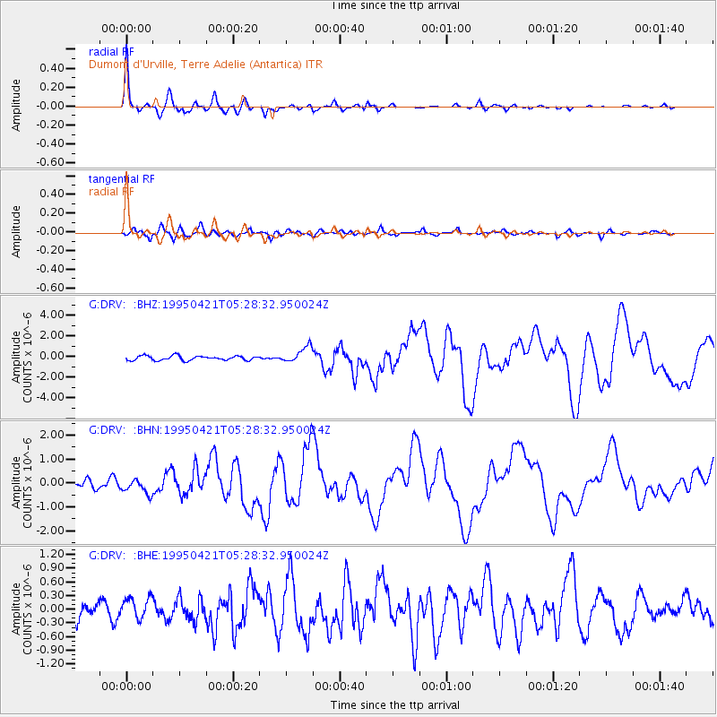
Signal To Noise
| Channel | StoN | STA | LTA |
| G:DRV: :BHN:19950421T05:28:32.950024Z | 1.5704646 | 3.099031E-7 | 1.9733211E-7 |
| G:DRV: :BHE:19950421T05:28:32.950024Z | 1.1287717 | 2.3821526E-7 | 2.1103938E-7 |
| G:DRV: :BHZ:19950421T05:28:32.950024Z | 3.5981452 | 7.770707E-7 | 2.1596422E-7 |
| Arrivals |
| Ps | 4.2 SECOND |
| PpPs | 17 SECOND |
| PsPs/PpSs | 21 SECOND |


