You are here: Home > Network List > TA - USArray Transportable Network (new EarthScope stations) Stations List
> Station H35A Sunnyside Ranch, Fairfax, MN, USA > Earthquake Result Viewer
H35A Sunnyside Ranch, Fairfax, MN, USA - Earthquake Result Viewer

| Earthquake location: |
Off Coast Of Chiapas, Mexico |
| Earthquake latitude/longitude: |
14.4/-94.7 |
| Earthquake time(UTC): |
2011/08/13 (225) 07:33:06 GMT |
| Earthquake Depth: |
6.0 km |
| Earthquake Magnitude: |
5.7 MB, 5.2 MS, 5.8 MW, 5.6 MW |
| Earthquake Catalog/Contributor: |
WHDF/NEIC |
|
| Network: |
TA USArray Transportable Network (new EarthScope stations) |
| Station: |
H35A Sunnyside Ranch, Fairfax, MN, USA |
| Lat/Lon: |
44.70 N/94.83 W |
| Elevation: |
345 m |
|
| Distance: |
30.2 deg |
| Az: |
359.777 deg |
| Baz: |
179.697 deg |
| Ray Param: |
0.07939825 |
| Estimated Moho Depth: |
37.25 km |
| Estimated Crust Vp/Vs: |
2.10 |
| Assumed Crust Vp: |
6.571 km/s |
| Estimated Crust Vs: |
3.133 km/s |
| Estimated Crust Poisson's Ratio: |
0.35 |
|
| Radial Match: |
88.33708 % |
| Radial Bump: |
400 |
| Transverse Match: |
70.34862 % |
| Transverse Bump: |
400 |
| SOD ConfigId: |
410809 |
| Insert Time: |
2012-01-06 04:57:24.349 +0000 |
| GWidth: |
2.5 |
| Max Bumps: |
400 |
| Tol: |
0.001 |
|
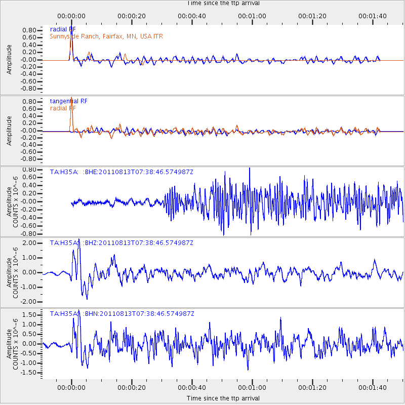
Signal To Noise
| Channel | StoN | STA | LTA |
| TA:H35A: :BHZ:20110813T07:38:46.574987Z | 17.801743 | 1.1153654E-6 | 6.265484E-8 |
| TA:H35A: :BHN:20110813T07:38:46.574987Z | 14.200592 | 8.3192543E-7 | 5.8583858E-8 |
| TA:H35A: :BHE:20110813T07:38:46.574987Z | 4.945738 | 2.0550917E-7 | 4.155278E-8 |
| Arrivals |
| Ps | 6.7 SECOND |
| PpPs | 16 SECOND |
| PsPs/PpSs | 23 SECOND |


