You are here: Home > Network List > G - GEOSCOPE Stations List
> Station DRV Dumont d'Urville, Terre Adelie (Antartica) > Earthquake Result Viewer
DRV Dumont d'Urville, Terre Adelie (Antartica) - Earthquake Result Viewer
| Earthquake location: |
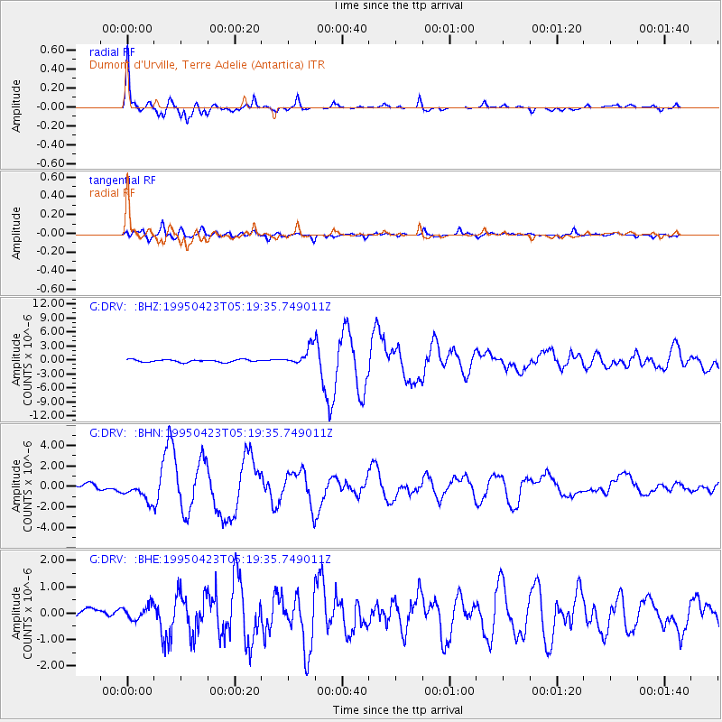
Samar, Philippines |
| Earthquake latitude/longitude: |
12.4/125.4 |
| Earthquake time(UTC): |
1995/04/23 (113) 05:08:03 GMT |
| Earthquake Depth: |
33 km |
| Earthquake Magnitude: |
6.0 MB, 6.6 MS, 6.7 UNKNOWN, 6.7 MW |
| Earthquake Catalog/Contributor: |
WHDF/NEIC |
|
| Network: |
G GEOSCOPE |
| Station: |
DRV Dumont d'Urville, Terre Adelie (Antartica) |
| Lat/Lon: |
66.67 S/140.01 E |
| Elevation: |
40 m |
|
| Distance: |
79.6 deg |
| Az: |
174.122 deg |
| Baz: |
345.451 deg |
| Ray Param: |
0.048832458 |
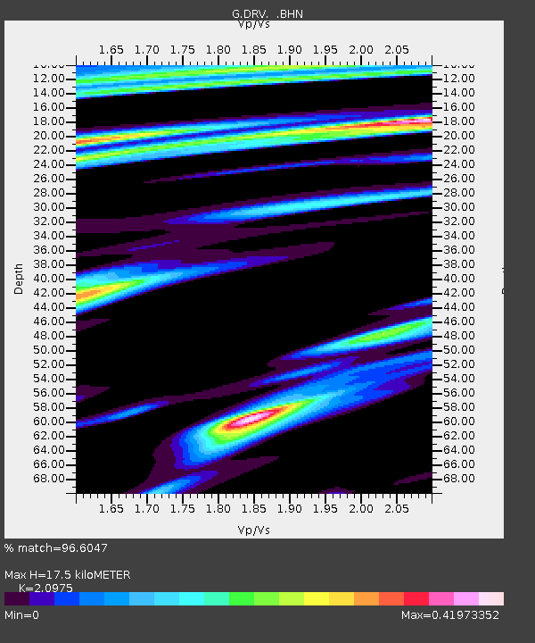
| Estimated Moho Depth: |
17.5 km |
| Estimated Crust Vp/Vs: |
2.10 |
| Assumed Crust Vp: |
6.39 km/s |
| Estimated Crust Vs: |
3.046 km/s |
| Estimated Crust Poisson's Ratio: |
0.35 |
|
| Radial Match: |
96.6047 % |
| Radial Bump: |
400 |
| Transverse Match: |
90.4833 % |
| Transverse Bump: |
400 |
| SOD ConfigId: |
6273 |
| Insert Time: |
2010-02-26 22:01:47.866 +0000 |
| GWidth: |
2.5 |
| Max Bumps: |
400 |
| Tol: |
0.001 |
|
Signal To Noise
| Channel | StoN | STA | LTA |
| G:DRV: :BHN:19950423T05:19:35.749011Z | 3.6530201 | 9.922397E-7 | 2.7162176E-7 |
| G:DRV: :BHE:19950423T05:19:35.749011Z | 0.8692959 | 2.6380002E-7 | 3.03464E-7 |
| G:DRV: :BHZ:19950423T05:19:35.749011Z | 7.282675 | 1.9399317E-6 | 2.6637628E-7 |
| Arrivals |
| Ps | 3.1 SECOND |
| PpPs | 8.3 SECOND |
| PsPs/PpSs | 11 SECOND |


