You are here: Home > Network List > US - United States National Seismic Network Stations List
> Station MNTX Cornudas Mountains, Texas, USA > Earthquake Result Viewer
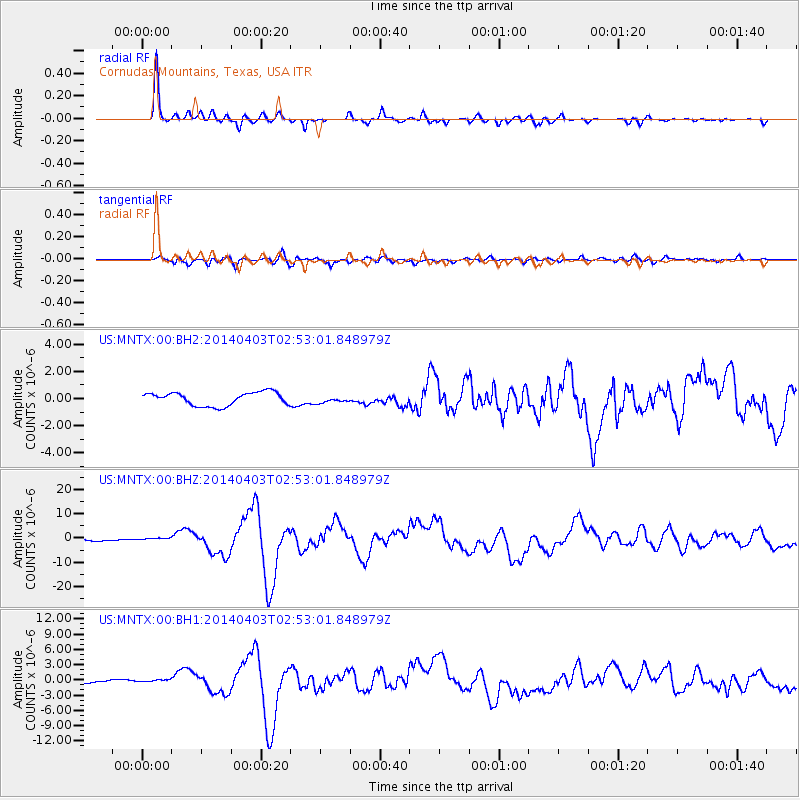
MNTX Cornudas Mountains, Texas, USA - Earthquake Result Viewer
*The percent match for this event was below the threshold and hence no stack was calculated.
| Earthquake location: |
Near Coast Of Northern Chile |
| Earthquake latitude/longitude: |
-20.5/-70.5 |
| Earthquake time(UTC): |
2014/04/03 (093) 02:43:14 GMT |
| Earthquake Depth: |
31 km |
| Earthquake Magnitude: |
7.7 MWW, 7.4 MI, 7.7 MWC |
| Earthquake Catalog/Contributor: |
NEIC PDE/NEIC COMCAT |
|
| Network: |
US United States National Seismic Network |
| Station: |
MNTX Cornudas Mountains, Texas, USA |
| Lat/Lon: |
31.70 N/105.38 W |
| Elevation: |
404 m |
|
| Distance: |
61.8 deg |
| Az: |
326.401 deg |
| Baz: |
142.517 deg |
| Ray Param: |
$rayparam |
*The percent match for this event was below the threshold and hence was not used in the summary stack. |
|
| Radial Match: |
94.141396 % |
| Radial Bump: |
328 |
| Transverse Match: |
78.029686 % |
| Transverse Bump: |
400 |
| SOD ConfigId: |
3390531 |
| Insert Time: |
2019-04-11 02:13:01.695 +0000 |
| GWidth: |
2.5 |
| Max Bumps: |
400 |
| Tol: |
0.001 |
|
Signal To Noise
| Channel | StoN | STA | LTA |
| US:MNTX:00:BHZ:20140403T02:53:01.848979Z | 1.9724183 | 6.5044867E-7 | 3.297722E-7 |
| US:MNTX:00:BH1:20140403T02:53:01.848979Z | 0.6930365 | 2.1195162E-7 | 3.0583038E-7 |
| US:MNTX:00:BH2:20140403T02:53:01.848979Z | 0.69637424 | 3.459097E-7 | 4.967296E-7 |
| Arrivals |
| Ps | |
| PpPs | |
| PsPs/PpSs | |


