You are here: Home > Network List > NE - New England Seismic Network Stations List
> Station HNH Hanover, NH > Earthquake Result Viewer
HNH Hanover, NH - Earthquake Result Viewer
| Earthquake location: |
Ecuador |
| Earthquake latitude/longitude: |
-1.8/-76.9 |
| Earthquake time(UTC): |
2011/08/15 (227) 02:53:18 GMT |
| Earthquake Depth: |
177 km |
| Earthquake Magnitude: |
5.7 MB, 5.7 MW, 5.7 MW |
| Earthquake Catalog/Contributor: |
WHDF/NEIC |
|
| Network: |
NE New England Seismic Network |
| Station: |
HNH Hanover, NH |
| Lat/Lon: |
43.71 N/72.29 W |
| Elevation: |
180 m |
|
| Distance: |
45.5 deg |
| Az: |
4.699 deg |
| Baz: |
186.483 deg |
| Ray Param: |
0.070580184 |
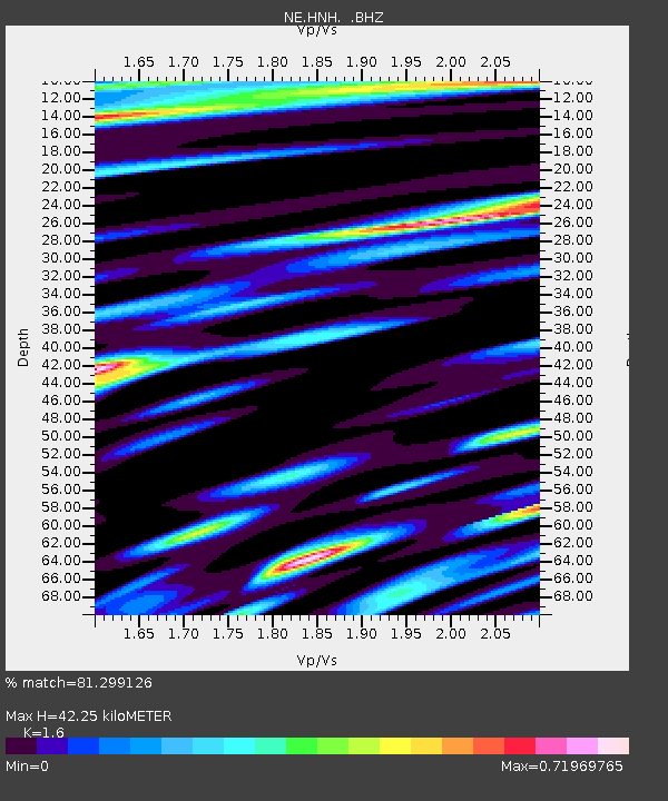
| Estimated Moho Depth: |
42.25 km |
| Estimated Crust Vp/Vs: |
1.60 |
| Assumed Crust Vp: |
6.419 km/s |
| Estimated Crust Vs: |
4.012 km/s |
| Estimated Crust Poisson's Ratio: |
0.18 |
|
| Radial Match: |
81.299126 % |
| Radial Bump: |
400 |
| Transverse Match: |
56.015266 % |
| Transverse Bump: |
400 |
| SOD ConfigId: |
410809 |
| Insert Time: |
2012-01-06 05:19:08.824 +0000 |
| GWidth: |
2.5 |
| Max Bumps: |
400 |
| Tol: |
0.001 |
|

Signal To Noise
| Channel | StoN | STA | LTA |
| NE:HNH: :BHZ:20110815T03:00:49.800015Z | 2.9906862 | 3.210361E-7 | 1.073453E-7 |
| NE:HNH: :BHN:20110815T03:00:49.800015Z | 2.096987 | 1.5332643E-7 | 7.311749E-8 |
| NE:HNH: :BHE:20110815T03:00:49.800015Z | 0.8080955 | 6.7259734E-8 | 8.323241E-8 |
| Arrivals |
| Ps | 4.2 SECOND |
| PpPs | 16 SECOND |
| PsPs/PpSs | 20 SECOND |


